Martin Rd Falls – 2 Waterfalls
AKA: |
—– |
Location: |
Webb Twn |
First Visit: |
6/27/2016 |
Region: |
Central |
County: |
Herkimer |
Park/Area: |
—– |
Gps of Falls: |
—– |
Gps of Parking: |
N43.82195 W74.88087 |
Gps of Trailhead: |
—– |
Trail Name/Reference to: |
—– |
Landmark: |
—– |
Stream/River/Watershed: |
Unnamed Tributaries |
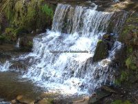
Height of Falls/Type: |
45 ft and 25 ft, Plunge Cascade |
Elevation: |
1950 ft |
Level of Difficulty/Hiking Distance: |
Roadside |
Wikiloc: |
—– |
Whitewater Rte/Canoe Rte Map: |
—– |
Maps: |
—– |
Trails Websites: |
—– |
My Resource: |
Russell Dunn |
Book Resource: |
—– |
Brochures/Travel Guides/Visitor Guides: |
—– |
Additional Information: |
—– |
Photos And Information I Contributed To or Posted To Other Websites: |
Digthefalls |
Nearest Intersection: |
Martin Rd and Big Moose Rd |
Directions: |
From County Rte 28 and Big Moose Rd, in Eagle Bay, Get on Big Moose Rd and drive north for 5.8 miles. Turn right onto Martin Rd, and drive 0.2 miles to the first waterfall on your left. Continue another 0.2 mile, and the second waterfall will also be on your left. |
Comments/Notes: |
—– |
For more information please click on the following links
Martin Rd Falls on #1
Martin Rd Falls on #2