
Robert H. Treman State Park – Enfield Creek And Glen Waterfalls
Robert H Treman State Park, Enfield Creek and Glen Waterfalls
Tompkins County New York Enfield Town,Enfield Glen, also known as Treman Gorge. Stream or River: Enfield Creek flows into Cayuga Lake Inlet
Named Waterfalls in Enfield Glen:
Fish Kill Falls (Enfield Glen), Enfield Lower Falls aka Enfield Creek And Glen Falls, Sulphur Falls (Enfield Glen), Lucifer Falls (Enfield Glen)
Dates Visited:
7/15/2006 9/02/2006 5/06/2012
I have yet to complete the entire Gorge trail. I have included all the resource information that I have. I cannot confirm exact location since I have not hiked the whole trail. Google imagery shows the falls very clearly. If the information I provided here is different or wrong, or you have additional information to provide, feel free to let me know.
Maps and Resources used to gather information:
Western New York all outdoors Atlas & Field Guide Publication 2008 103 C5
200 Waterfalls In Central & Western New York “A Finders’ Guide” By Rich And Sue Freeman 2002
New York Waterfalls “A Guide For Hikers & Photographers” by Scott E. Brown 2010
Robert H. Treman State Park
http://nyfalls.com/waterfalls/robert-treman-state-park/
http://www.nysparks.com/parks/attachments/RobertHTremanTrailMap.pdf
http://naturalbornhikers.com/trails/roberthtreman.html
Directions:
From Ithaca, take NYS route 13 south about 5 miles to the junction with NYS route 327 on the right. At this point you will see a sign for the Park. Turn right onto 327, and then immediately turn left into the park. To reach the upper parking area, continue about 2 and a half miles on 327. The upper entrance will be on the left. Follow the park road to the upper parking area.
Length of Hike:
CCC – CCC Memorial Trail Blue .49 Miles, FLT – Finger Lakes Trail/North Country Trail White 5.15 Miles, GO – Gorge Trail 2.12 Miles, RP – Red Pine Trail .79 Miles, RM – Rim Trail Blue 2.09 Miles
Parking areas:
Enfield Glen Upper Parking N42.40221 W76.59022
Lower Parking Area 1 N42.39798 W76.55653
Lower Parking Area 2 N42.39692 W76.55631
Lower Parking Area 3 N42.39613 W76.55761
Lower Parking Area 4 N42.39602 W76.55565
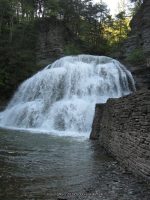
Enfield Lower Falls
Different resources has indicated different height for Lower Falls. From lower parking lot walk through the picnic and playground area to get to the falls.
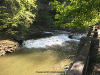
Falls Below Lower Falls (Enfield Glen) Can See This Just Before Reaching Lower Falls This is a small dam. N42.39691 W76.56030
At the lowermost portion of the park (parking lot) is a small fall N42.39733 W76.55698
Falls: N42.39727 W76.56126
Landmark: Above the swimming area
Height: 32 ft to 70 ft
Elevation: 550 ft
Type: Bastion
Fish Kill Falls (Enfield Glen) Fishkill Creek
From the parking lot go over behind the mill. Also as you are coming down the Upper Park Road, Enfield Creek runs along the left side of the road. There are some small waterfalls in this section. N42.40334 W76.59386
Falls: N42.40157 W76.58989
Landmark: The Old Mill
Height: 12 ft
Elevation: 936 ft
Type: Cascade
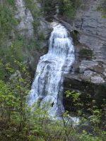
Lucifer Falls (Enfield Glen) Gorge Trail
Falls: N42.40019 W76.58371
Height: 115 ft
Elevation: 828 ft
Type: Freefall Cascade
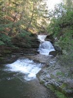
Sulphur Falls (Enfield Glen) Red Pine Trail
About .2 miles upstream from the Lower Falls or about .4 miles below Sulphur Falls, is a waterfall N42.39843 W76.56540.
Falls: N42.39994 W76.57190
Elevation: 655 ft
Upper Park Area starting from the top working down to Sulphur Falls
Small Falls N42.41075 W76.60750 994 ft
Enfield Glen Upper Section (Along left side of Upper Park Rd heading to parking area) N42.40334 W76.59386 935 ft
Fish Kill Falls (Enfield Glen) N42.40157 W76.58989 936 ft
Small Falls N42.40125 W76.58587 934 ft
Lucifer Falls above N42.40053 W76.58475 888 ft
Lucifer Falls N42.40019 W76.58371 828 ft
Lucifer Falls bottom N42.40032 W76.58332 808 ft
Falls N42.40019 W76.58159 711 ft
Falls N42.39987 W76.58047 704 ft
Falls N42.39988 W76.57832 685 ft
Falls N42.39974 W76.57734 697 ft
Sulphur Falls N42.39994 W76.57190 655 ft
Sulphur Falls falls below N42.40004 W76.56991 631 ft
Lower Park Area starting from the beginning up to Sulphur Falls
Small Falls N42.39733 W76.55698 474 ft
Falls Below Lower Falls N42.39691 W76.56030 500 ft
Lower Falls aka Enfield Creek And Glen Falls N42.39727 W76.56126 525 ft
Falls above Lower Falls N42.39747 W76.56146 550 ft
Waterfall 1 N42.39756 W76.56283 594 ft
Waterfall 2 N42.39810 W76.56399 598 ft
Waterfall 3 N42.39843 W76.56540 603 ft
Waterfall 4 N42.39878 W76.56675 632 ft
