
Waterfalls of New York State 100+ Challenge, Dig the Falls, part 2, The Hudson Valley Region For more information on this challenge click here To purchase “Waterfalls of New York State”, click here To purchase “A Waterfall Guide to Letchworth State Park” by Scott A. Ensminger and Douglas K. Bassett, click here
The following list is the first set of locations listed in the book “Waterfalls of New York State” by Scott A. Ensminger (Western New York Waterfall Survey), David J. Schryver (Northern New York Waterfalls) and Edwards M. Smathers (Dig the Falls) Be sure to check them out! I myself have personally contributed a lot of waterfall location information to both Mr. Edward Smathers and Mr. David Schryver. I am currently a team member with “Dig the Falls”. The simple rules of this challenge, is to visit 100 waterfall locations in the book. One location may have several waterfalls, but counts as one location. Click on the links (I have visited) in the boxes below, which will take you to additional information pages.
As you will notice, I really have to work on my Southern Waterfalls! Jump on over to Digthefalls for additional information on the other waterfalls listed here below.
Additional Falls in location, or close by |
Waterfall Name, info |
Date First visited |
County |
….. |
Artist Falls Winter Clove Platform View 15′ |
….. |
Greene |
additional falls |
Countryman Kill, Falls #1 3.3 rt public small 5′ cascade on top with a 10′ plunge waterfall at the bottom |
….. |
Greene |
additional falls |
Countryman Kill, Falls #2 3.3 rt public 14′ plunge |
….. |
Greene |
additional falls |
Countryman Kill, Falls #3 3.3 rt public 15′ plunge |
….. |
Greene |
additional falls |
Countryman Kill, Falls #4 3.3 rt public 26′ plunge |
….. |
Greene |
additional falls |
Countryman Kill, Falls #5 Countryman Kill possible private 19′ cascade |
….. |
Greene |
additional falls |
Winter Clove Falls Winter Clove 3.6 mile rt 70′ Total |
….. |
Greene |
 |
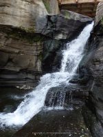
Kaaterskill Falls Kaaterskill Clove/Lake Creek Ravine aka Catterskill Falls, Cauterskill Falls Roadside view/1.5 mile rt 230′ Total |
Visited 8/18/2013 |
Greene |
additional falls  |
Bastion Falls Kaaterskill Clove/Lake Creek Ravine aka Sebation Falls, Horse shoe Falls, Rip Van Winkle Falls Roadside View/.2 mile walk along the roadside 71′ Cascade |
Visited 8/18/2013 |
Greene |
 |
Plattekill Falls Platte Clove aka Plaaterskill Falls, Pomeroy Falls .2 mile/several small cascades above 75′ (some sources state 51′) |
Visited 8/18/2013 |
Greene |
additional falls |
Black Chasm Falls Platte Clove aka Everits Cascade, Platte Clove Falls 5.5 miles Rt for all waterfalls on the Plattkill Creek 100′ |
….. |
Greene |
additional falls |
Blue Hole Falls Platte Clove 5.5 miles Rt for all waterfalls on the Plattkill Creek |
….. |
Greene |
additional falls |
Bridal Veil Falls Platte Clove Hard Dangerous Approx. 1.8 Mile Rt/Can be seen best by overlook at Hells Hole N42.13066 W74.08354 Trailhead N42.13323 W74.0859490′ |
Visited 8/18/2013 |
Greene |
additional falls |
Evergreen Falls Platte Clove aka Gray Rock Falls, Green Falls, Lower Platte-kill Falls Roadside View/5.5 miles Rt for all waterfalls on the Plattkill Creek 40′ |
….. |
Greene |
additional falls |
Gray Rock Falls Platte Clove aka Evergreen Falls, Green Falls, Lower Platte-kill Falls Gps location is based upon gathered sorces 5.5 miles Rt for all waterfalls on the Plattkill Creek |
….. |
Greene |
additional falls |
Green Falls Platte Clove aka Evergreen Falls, Gray Rock Falls, Lower Platte-kill Falls, The Ghost Gps location is based upon gathered sorces 5.5 miles Rt for all waterfalls on the Plattkill Creek 20′ to 50′ approx |
….. |
Greene |
additional falls |
Grey Rock Falls Platte Clove aka Horseshoe Bend Falls Roadside View/5.5 miles Rt for all waterfalls on the Plattkill Creek |
….. |
Greene |
additional falls |
Hells Hole Falls #1 Platte Clove aka The Devils Kitchen Falls Roadside Views/.2 mile Rt Falls in Close Proximity 4′ |
….. |
Greene |
additional falls |
Hells Hole Falls #2 Platte Clove aka The Devils Kitchen Falls Roadside Views/.2 mile Rt Falls in Close Proximity cascade |
….. |
Greene |
additional falls |
Hells Hole Falls #3 Platte Clove aka The Devils Kitchen Falls Roadside Views/.2 mile Rt 4′-5′ cascade |
….. |
Greene |
additional falls |
Japanese Falls Platte Clove 5.5 miles Rt for all waterfalls on the Plattkill Creek 20’/20’/80′ |
….. |
Greene |
additional falls  |
Visited 8/18/2013 |
Greene |
|
additional falls |
Pomeroy Falls Platte Clove According to resources, this waterfall is stated to be one of the three largest falls, based on the order of waterfalls, this maybe an aka of Plattekill Falls. 5.5 miles Rt for all waterfalls on the Plattkill Creek Individual GPS unknown….. |
….. |
Greene |
additional falls |
Rainbow Falls Platte Clove Roadside view 5.5 miles Rt for all waterfalls on the Plattkill Creek 50′ |
….. |
Greene |
additional falls |
Rainbow Falls, Lower Platte Clove aka Hell Hole Falls, Japanese Falls, Upper Roadside view/5.5 miles Rt for all waterfalls on the Plattkill Creek 20’/20’/80′ Total with Japanese Falls |
….. |
Greene |
additional falls |
Red Falls, Upper Platte Clove aka Red Rock Falls, Honoulu Falls, Twins Falls, Reds Falls, Carns Falls 5.5 miles Rt for all waterfalls on the Plattkill Creek |
….. |
Greene |
additional falls |
Red Rock Falls, Lower Platte Clove aka Honoulu Public – State Land 35′ |
….. |
Greene |
additional falls |
Red Rock Falls, Upper Platte Clove aka Gray Rock Falls Roadside View 25′ |
….. |
Greene |
additional falls |
Rocky Rapids Platte Clove Location is based on gathered resources 5.5 miles Rt for all waterfalls on the Plattkill Creek Individual GPS unknown |
….. |
Greene |
….. |
High Falls High Falls Conservation Area 1.5 mile loop 80′ |
….. |
Columbia |
additional falls |
Agawamuck Falls High Falls Conservation Area aka Ackawamack Falls http://clctrust.org/discover/public-conservation-areas/ discover-our-places-high-falls/ 70′-80′ |
….. |
Columbia |
additional falls |
Unnamed Falls High Falls Conservation Area Part of Dam, Philmont Dam 1.5 mile loop 15′-20′ |
….. |
Columbia |
….. |
Bash Bish Falls Taconic State Park 5 mile – crossing into MA 80′ Total |
….. |
Columbia |
additional falls |
Copake Falls Taconic State Park https://parks.ny.gov/parks/attachments/ TaconicCopakeFallsAreaTrailMap-NorthernSection.pdf/ Individual GPS unknown |
…….. |
Columbia |
— |
High Falls High Falls Historic District aka Great Falls .1 mile 25′ |
….. |
Ulster |
— |
Awosting Falls Minnewaska State Park Inside State park .6 mile/Designated Carriage Roads/Red 1.4 https://parks.ny.gov/parks/attachments/ SamPointAreaMinnewaskaStateParkTrailMap.pdf60′ |
….. |
Ulster |
additional falls |
Coxing Kill, Falls on Lower Minnewaska State Park |
….. |
Ulster |
additional falls |
Coxing Kill, Falls on Tributary to Minnewaska State Park |
….. |
Ulster |
additional falls |
High Peters Kill Waterfall Minnewaska State Park https://www.alltrails.com/explore/recording/high-peters-kill-trail–33….. |
….. |
Ulster |
additional falls |
Rainbow Falls Minnewaska State Park/Sam’s Point 3.4 Miles 1-Way 75′ |
….. |
Ulster |
additional falls |
Sanders Kill, Falls on Minnewaska State Park 6 mile rt/1.6 mile rt 8’/4′ |
….. |
Ulster |
additional falls |
Saw Mill Falls Minnewaska State Park 1.4 Mile Rt 18′ |
….. |
Ulster |
additional falls |
Split Rock Falls Minnewaska State Park aka Coxing Kill Falls .1 mile 8′ |
….. |
Ulster |
additional falls |
Stony Kill Falls Minnewaska State Park 5 mile 135′ Total |
….. |
Ulster |
….. |
Verkeerder Kill Falls Sams Point preserve aka Kittykill Falls, Kaidy Kill Falls, Katy Kill Falls 5.6 mile RT Fee Required 72′ |
….. |
Ulster |
additional falls |
South Gully, Diana’s Pool Sam’s Point/South Gully Approx 6 mile Rt |
….. |
Ulster |
additional falls |
South Gully, Falls on #01 Sam’s Point/South Gully Approx 6 mile Rt |
….. |
Ulster |
additional falls |
South Gully, Falls on #02 Sam’s Point/South Gully Approx 6 mile Rt |
….. |
Ulster |
additional falls |
South Gully, Falls on #03 Sam’s Point/South Gully Approx 6 mile Rt |
….. |
Ulster |
additional falls |
South Gully, Falls on #04 Sam’s Point/South Gully Approx 6 mile Rt |
….. |
Ulster |
….. |
Dover Stone Church Cave Falls .5 mile 35′ |
….. |
Dutchess |
additional falls |
Seven Wells, The Access not yet verified |
….. |
Dutchess |
….. |
Fitzgerald Falls .3 mile Appalation Trail 30′ |
….. |
Orange |
 |
Visited 8/10/2014 |
Delaware |
|
additional falls  |
Visited 8/10/2014 |
Delaware |
|
….. |
Buttermilk Falls #1. Private/No Access 25′ |
….. |
Chenango |
additional falls  |
Visited 8/8/2014/not in same location as the other 4 falls, which are farther north |
Chenango |
|
additional falls |
Buttermilk Falls #2 Private/No Access 25′ |
….. |
Chenango |
additional falls |
Buttermilk Falls #3 Private/No Access 25′ |
….. |
Chenango |
additional falls |
Buttermilk Falls #4 Private/No Access 25′ |
….. |
Chenango |


 GREEN COUNTY SOUTHERN NEW YORK 8-17-2013_00003.JPG")
 GREEN COUNTY SOUTHERN NEW YORK 8-17-2013_00007.JPG")


GREEN COUNTY SOUTHERN NEW YORK 8-18-2013_00006.JPG")
 GREEN COUNTY SOUTHERN NEW YORK 8-18-2013_00004.JPG")


 GREEN COUNTY SOUTHERN NEW YORK 8-18-2013_00001.JPG")
 GREEN COUNTY SOUTHERN NEW YORK 8-18-2013_00002.JPG")

