Artist Falls and Gill Brook Trail Waterfalls
Artist Falls and Gill Brook Trail Waterfalls (St Huberts)
AKA: |
—– |
Location: |
Keene Twn |
First Visit: |
8/11/2011 |
Region: |
Northern |
County: |
Essex |
Park/Area: |
—– |
Gps of Falls: |
N44.12673 W73.80830 |
Gps of Parking: |
N44.14903 W73.77027 |
Gps of Trailhead: |
—– |
Trail Name/Reference to: |
—– |
Landmark: |
—– |
Stream/River/Watershed: |
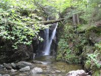
Gill Brook |
Height of Falls/Type: |
10 ft, to 20 ft, Cascade |
Elevation: |
1811 ft |
Level of Difficulty/Hiking Distance: |
0.5 |
Wikiloc: |
—– |
Whitewater Rte/Canoe Rte Map: |
—– |
Maps: |
Eastern New York all outdoors Atlas & Field Guide Publication 2008 |
Trails Websites: |
—– |
My Resource: |
Eastern New York all outdoors Atlas & Field Guide Publication 2008 |
Book Resource: |
|
Brochures/Travel Guides/Visitor Guides: |
—– |
Additional Information: |
|
Photos And Information I Contributed To or Posted To Other Websites: |
—– |
Nearest Intersection: |
St Huberts Rd and Ausable Club Rd and Lake Rd |
Directions: |
From I-87 N in North Hudson, Take exit 30 to the right onto US-9 towards Rt-73/Keene Valley/Keene and drive for .2 miles. Turn left onto US 9 and drive for 2.2 miles. Keep left onto Hwy 73 N and drive for 5.4 miles. Turn left onto Ausable Rd and drive for .2 miles to the parking area. |
Comments/Notes: |
Waterfalls on the Gill Brook
#1 15 ft Block N44.12480 W73.80906
#2 Chute N44.12397 W73.80948
#4 15 ft Flume N44.12293 W73.80988
#5 9 ft Cascade N44.12247 W73.81003
#6 25 ft N44.12198 W73.81019
#7 Flume N44.12148 W73.81035
#8 Long Slide N44.12080 W73.81075
#9 10 ft N44.11999 W73.81125
Home » Artist Falls and Gill Brook Trail Waterfalls » Artist Falls and Gill Brook Trail (waterfalls on) St Huberts