
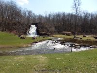
Waterfall Name: Glen Falls (Holley)
Aka: Holley Canal Falls, Holley Falls
Location: Holley
First Visit: 04-12-2014
State: New York State
Region: Western Region
County: Orleans County
Park Area: Public Park
NYS Tourism Region: Niagara Frontier
NYDEC Region: Western Finger Lakes
Waterfall Challenge: ————-
Waterfall Location: N43.22506 W78.01836
Parking: N43.225495 W78.019337
Trailhead: ————-
Trail Name, Reference to: ————-
Stream, River: East Branch Sandy Creek
Height, Type: 30ft,Cascade
Elevation: 478 ft
Level of Difficulty, Hiking Distance: Roadside or short walk down to the falls
Whitewater Rte, Canoe Rte Map: ————-
Maps: Western New York All-Outdoors Atlas & Field Guide, 2008,C1,pg142
My Resource: Western New York All-Outdoors Atlas & Field Guide, 2008,C1,pg142
Book Resource: 200 Waterfalls in Central and Western New York: A Finder’s Guide Paperback – June 5, 2018, by Rich and Sue Freeman,Waterfalls in Niagara, Erie, Orleans, Genesee & Wyoming Counties,pg44
Brochures, Travel Guides, Visitor Guides: ————-
Trail_URL: ————-
Additional Information: falzguy
Photos, Information Contributed to other Websites: Dig the Falls
Landmark: Village Dpw
Nearest Intersection: Holley Square and Thomas Street and Frisbee Terrace Drive
Directions: From I-90 W in Batavia, Take exit 48 to the right onto Rt-98 towards Batavia and drive for .9 miles. Take the Rt-98 N ramp to the right towards Albion and drive for 3.6 miles. Turn right onto Hwy 262 and drive for 5.6 miles. Turn left onto Byron Rd and drive for 1.4 miles. Turn left onto Hwy 237 and drive for .5 miles. Keep left onto Hwy 237 and drive for 9.1 miles. Keep right onto Batavia St and drive for .1 miles. Turn left onto Mechanic St and drive for .1 miles. Turn right onto White St and drive for .3 miles. Turn right onto East Ave for 238 ft. Turn right onto Erie Canal Trl and drive for .3 miles.
Comments, Notes: This is a very nice park.
————-
————-
————-