
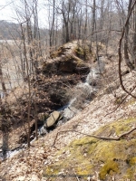
Waterfall Name: Turning Point Park Falls – South Falls
Aka: Turning Point Park Falls, Browns Falls, Red Rock Falls, Bullock’s Falls
Location: Rochester
First Visit: 04-12-2014
State: New York State
Region: Western Region
County: Monroe County
Park Area: Turning Point Park
NYS Tourism Region: Finger Lakes-Wine Country
NYDEC Region: Western Finger Lakes
Waterfall Challenge: ————-
Waterfall Location: N43.22396 W77.61774
Parking: N43.227611 W77.617894
Trailhead: N43.227251 W77.617711
Trail Name, Reference to: ————-
Stream, River: Unnamed tributary to the Genesee River
Height, Type: 33ft Gradual Cascade
Elevation: 250 ft
Level of Difficulty, Hiking Distance: 1.0 Mile rt, near the cement rremains of an observation platform.
Whitewater Rte, Canoe Rte Map: ————-
Maps: Western New York All-Outdoors Atlas & Field Guide, 2008,D5,pg143
My Resource: Western New York All-Outdoors Atlas & Field Guide, 2008,D5,pg143
Book Resource: 200 Waterfalls in Central and Western New York: A Finder’s Guide Paperback – June 5, 2018, by Rich and Sue Freeman,Waterfalls in Monroe, Livingston and Ontario Counties,pg141
Brochures, Travel Guides, Visitor Guides: ————-
Trail_URL: ————-
Additional Information: Http://www.nyfalls.com
Photos, Information Contributed to other Websites: ————-
Landmark: The Cement Remains Of An Observation Platform.
Nearest Intersection: Lake Ave and Boxart Street
Directions: From I-90 W in Henrietta, Take exit 46 to the right onto I-390 towards Rochester/Corning and drive for .4 miles. Take the I-390 N ramp to the left towards Rochester and drive for .5 miles. Take the I-390 N ramp to the left towards Rochester and drive for 4.7 miles. Keep left onto I-390 N towards Airport/Greece and drive for .9 miles. Continue on I-390 N towards Airport/Greece and drive for 4.9 miles. Continue on I-390 N and drive for 3.6 miles. Take exit 24A to the right onto Ridge Rd towards Rt-104 E and drive for .6 miles. Turn left onto Stone Rd and drive for 2.9 miles. Turn right onto Lake Ave and drive for .3 miles. Turn left onto Boxart St. and drive for .1 miles. Turn right onto Boxart St. and drive for .3 miles. Turn left onto Unpaved Rd and drive for .1 miles.
Comments, Notes: I took some marker pics to show location. location of pipeline you walk under 43.226409, -77.617805. Continue walking till you reach this point N43.222409 W77.619089 where you will see the path that is on your left and follow that to the viewing platform. From the point of the pipeline and the formal trail turnoff you will see several points where folks have taken short cut to get down below. I feel you should keep to the main trails for all safety reasons.
————-
————-
————-