
Waterfall Name: Canaseraga Lower Falls
Aka: ————-
Location: Ossian Twn
First Visit: 08-12-2013
State: New York State
Region: Western Region
County: Livingston County
Park Area: ————-
NYS Tourism Region: Finger Lakes-Wine Country
NYDEC Region: Western Finger Lakes
Waterfall Challenge: ————-
Waterfall Location: N42.47442 W77.75242
Parking: N42.47348 W77.75565
Trailhead: ————-
Trail Name, Reference to: ————-
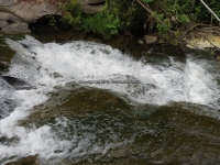
Stream, River: Canaseraga Creek
Height, Type: ————-
Elevation: 1187 ft
Level of Difficulty, Hiking Distance: Difficult short scramble down a steep embankment.
Whitewater Rte, Canoe Rte Map: ————-
Maps: ————-
My Resource: Western New York all outdoors Atlas & Field Guide Publication 2008
Book Resource: ————-
Brochures, Travel Guides, Visitor Guides: ————-
Trail_URL: ————-
Additional Information: World Waterfall Database
Photos, Information Contributed to other Websites: Dig the Falls
Landmark: ————-
Nearest Intersection: Co Rte 13b (Canaseraga Rd) and Faulkner Rd
Directions: From I-90 W in Henrietta, Take exit 46 to the right onto I-390 towards Rochester/Corning and drive for .4 miles. Take the I-390 S ramp to the right towards Corning and drive for 42.8 miles. Take exit 4 to the right onto Rt-36 towards Dansville/Hornell and drive for .4 miles. Turn right onto Hornell Rd and drive for 6 miles. Turn right onto Hwy 70 and drive for 1.4 miles. Turn right onto Perry Rd and drive for 1.2 miles.
Comments, Notes: This is a very steep climb down. There was a rope there for guidance. Down around the bend is Lower Falls.There is another set of falls further down stream and I am unsure if this may be the one resources is listing as Lower Falls. It is in Allegany County, Burn Town and Gps N42.47135 W77.74611
————-
————-
————-