
Waterfall Name: Ashantee Falls
Aka: ————-
Location: Avon Twn
First Visit: 08-12-2013
State: New York State
Region: Western Region
County: Livingston County
Park Area: ————-
NYS Tourism Region: Finger Lakes-Wine Country
NYDEC Region: Western Finger Lakes
Waterfall Challenge: ————-
Waterfall Location: N42.89864 W77.76444
Parking: N42.89818 W77.76389
Trailhead: ————-
Trail Name, Reference to: ————-
Stream, River: Conesus Creek
Height, Type: 10ft
Elevation: 553 ft
Level of Difficulty, Hiking Distance: Short
Whitewater Rte, Canoe Rte Map: ————-
Maps: Western New York All-Outdoors Atlas & Field Guide, 2008,D3,pg128
My Resource: Western New York All-Outdoors Atlas & Field Guide, 2008,D3,pg128
Book Resource: 200 Waterfalls in Central and Western New York: A Finder’s Guide Paperback – June 5, 2018, by Rich and Sue Freeman,Waterfalls in Monroe, Livingston and Ontario Counties,pg102
Brochures, Travel Guides, Visitor Guides: ————-
Trail_URL: ————-
Additional Information: ————-
Photos, Information Contributed to other Websites: Dig the Falls
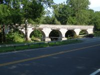
Landmark: 5 Stone Arch Bridge
Nearest Intersection: Route 39 and Littleville Rd and Cemetery Rd
Directions: From I-90 W in Henrietta, Take exit 46 to the right onto I-390 towards Rochester/Corning and drive for .4 miles. Take the I-390 S ramp to the right towards Corning and drive for 3.1 miles. Take exit 11 to the right onto Rt-15 towards Rt-251/Rush/Scottsville and drive for .3 miles. Take ramp to the left towards Rt-251 W for 207 ft. Turn left onto W Henrietta Rd and drive for 4.5 miles. Turn right onto Honeoye Falls No 6 Rd and drive for 1.3 miles. Turn left onto E River Rd and drive for 2.8 miles. Turn right onto W Main St for 440 ft. Turn left onto Wadsworth Ave and drive for 1.4 miles.
Comments, Notes: ————-
————-
————-
————-