
Waterfall Name: Morganville Falls
Aka: ————-
Location: Stafford
First Visit: 04-13-2014
State: New York State
Region: Western Region
County: Genesee County
Park Area: Small Town Park Northside Of Village
NYS Tourism Region: Niagara Frontier
NYDEC Region: Western Finger Lakes
Waterfall Challenge: ————-
Waterfall Location: N43.00550 W78.07464
Parking: N43.00429 W78.07368
Trailhead: Private
Trail Name, Reference to: ————-
Stream, River: Black Creek
Height, Type: 27ft
Elevation: 827 ft
Level of Difficulty, Hiking Distance: 10 Minute Roundtrip
Whitewater Rte, Canoe Rte Map: ————-
Maps: ————-
My Resource: World Waterfall Database
Book Resource: ————-
Brochures, Travel Guides, Visitor Guides: ————-
Trail_URL: ————-
Additional Information: ————-
Photos, Information Contributed to other Websites: ————-
Landmark: Hamlet Of Morganville
Nearest Intersection: Morganville Roand and Randall Rd
Directions: From I-90 W in LeRoy, Take exit 47 to the right onto I-490 towards Rt-19/Leroy/Rochester and drive for .6 miles. Take exit 1 to the right onto Rt-19 towards Le Roy/Brockport and drive for 2.7 miles. Turn right onto Randall Rd and drive for 4.8 miles.
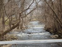
Comments, Notes: We were looking for Morganville Falls, but where they appear to be looked posted. The path or trail that looked to be the one, someone was starting to plant flower beds along it. So pictures shown here is what we found driving in this area of town. Resources state access is from cemetary. Access unknown
————-
————-
————-

The pictures you posted are not the Morganville falls. The falls are located in a deep ravine on the south side of calls pond
That is correct, I did not see Morganville Falls. The location I had for it brought me to a spot where I found it was posted and someone had started what appeared to be a garden and walkway. The photos posted with this was photos take in the area of Morganville. Thank you