
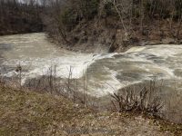
Waterfall Name: Indian Falls (Pembroke)
Aka: ————-
Location: Pembroke Twn
First Visit: 04-13-2014
State: New York State
Region: Western Region
County: Genesee County
Park Area: ————-
NYS Tourism Region: Niagara Frontier
NYDEC Region: Western Finger Lakes
Waterfall Challenge: ————-
Waterfall Location: N43.02669 W78.39935
Parking: N43.02626 W78.39900
Trailhead: ————-
Trail Name, Reference to: ————-
Stream, River: Tonawanda Creek
Height, Type: 20ft
Elevation: 750 ft
Level of Difficulty, Hiking Distance: Short
Whitewater Rte, Canoe Rte Map: ————-
Maps: Western New York All-Outdoors Atlas & Field Guide, 2008,B2,pg126
My Resource: Western New York All-Outdoors Atlas & Field Guide, 2008,B2,pg126
Book Resource: 200 Waterfalls in Central and Western New York: A Finder’s Guide Paperback – June 5, 2018, by Rich and Sue Freeman,Waterfalls in Niagara, Erie, Orleans, Genesee & Wyoming Counties,pg46
Brochures, Travel Guides, Visitor Guides: Indian Falls Log Cabin Restaurant
Trail_URL: ————-
Additional Information: Nyfalls
Photos, Information Contributed to other Websites: Dig the Falls
Landmark: Indian Falls Log Cabin Restaurant
Nearest Intersection: Gilmore Street
Directions: From I-90 W in Pembroke, Take exit 48A to the right onto Rt-77 towards Pembroke/Medina and drive for 1 miles. Turn left onto Alleghany Rd and drive for 1.7 miles. Turn left onto Gilmore Rd for 437 ft
Comments, Notes: When we stopped in here, there must of been a bike convention or something, because the place was jam packed. We did not go over to the little patio, and we could see the gate was closed, so we took what photos we could.
————-
————-
————-
