
Waterfall Name: Buttermilk Falls (Leroy)
Aka: ————-
Location: Leroy Twn
First Visit: 04-13-2014
State: New York State
Region: Western Region
County: Genesee County
Park Area: ————-
NYS Tourism Region: Niagara Frontier
NYDEC Region: Western Finger Lakes
Waterfall Challenge: ————-
Waterfall Location: N43.00523 W77.97340
Parking: ————-
Trailhead: ————-
Trail Name, Reference to: ————-
Stream, River: Oatka Creek
Height, Type: 60ft,Plunge
Elevation: 732 ft
Level of Difficulty, Hiking Distance: 30 Minute
Whitewater Rte, Canoe Rte Map: ————-
Maps: Western New York All-Outdoors Atlas & Field Guide, 2008,B1,pg128
My Resource: Western New York All-Outdoors Atlas & Field Guide, 2008,B1,pg128
Book Resource: ————-
Brochures, Travel Guides, Visitor Guides: On google maps
Trail_URL: ————-
Additional Information: Nyfalls
Photos, Information Contributed to other Websites: Dig the Falls
Landmark: Abandoned Railroad Trail
Nearest Intersection: Rte 19 Randall Rd and North Street Rd
Directions: From I-90 W in LeRoy, Take exit 47 to the right onto I-490 towards Rt-19/Leroy/Rochester and drive for .6 miles. Take exit 1 to the right onto Rt-19 towards Le Roy/Brockport and drive for 2.7 miles. Turn left onto North St Rd and drive for .3 miles.
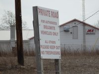
Comments, Notes: We stopped at a home there and the access is now totally private no access available. The area is now owned by Dolomite, as of 4-13-2014
————-
————-
————-
