
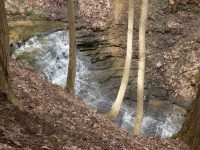
Waterfall Name: Emery Park South Falls
Aka: ————-
Location: Aurora Twn
First Visit: 04-13-2014
State: New York State
Region: Western Region
County: Erie County
Park Area: Emery County Park South End
NYS Tourism Region: Niagara Frontier
NYDEC Region: Western New York
Waterfall Challenge: ————-
Waterfall Location: N42.70917 W78.60078
Parking: N42.70928 W78.60407
Trailhead: N42.70928 W78.60407
Trail Name, Reference to: ————-
Stream, River: Unnamed Stream
Height, Type: 13ft
Elevation: 1200 ft
Level of Difficulty, Hiking Distance: Short
Whitewater Rte, Canoe Rte Map: ————-
Maps: Western New York All-Outdoors Atlas & Field Guide, 2008,B5,pg111
My Resource: Falzguy
Book Resource: ————-
Brochures, Travel Guides, Visitor Guides: Erie County Dept. of Parks, Recreation and Forestry, http://www2.erie.gov/parks/index.php?q=emery-park
Trail_URL: ————-
Additional Information: Erie County Dept. of Parks, Recreation and Forestry
Photos, Information Contributed to other Websites: Dig the Falls
Landmark: Campground Tent Site 11
Nearest Intersection: Emery Rd and Cornwall Rd
Directions: From I-90 W, Take exit 49 to the right onto Rt-78 towards Depew/Lockport and drive for .9 miles. Turn right onto Transit Rd and drive for 7.8 miles. Take the Rt-400 S ramp to the right and drive for 12.8 miles. Turn right onto Emery Rd and drive for 1.3 miles. Turn left onto Rd for 370 ft. Turn left onto Rd for 381 ft. Turn right onto Rd and drive for .4 miles.
Comments, Notes: We were directed to this waterfall by a couple of walkers in the park. They they just stated to watch for the huge tree at the fork and go left. It is a loop around in that section of the park.
————-
————-
————-