
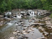
Waterfall Name: High Falls Road Extention, falls on, Kaaterskill Creek
Aka: ————-
Location: Catskill Twn
First Visit: 08-18-2013
State: New York State
Region: Southern Region
County: Greene County
Park Area: ————-
NYS Tourism Region: Catskill Mountains
NYDEC Region: Capital Region/Northern Catskills
Waterfall Challenge: ————-
Waterfall Location: N42.18555 W73.97265
Parking: N42.18441 W73.97124
Trailhead: ————-
Trail Name, Reference to: ————-
Stream, River: Kaaterskill Creek
Height, Type: Falls 6ft Dam 4ft,Dam and Falls
Elevation: 316 ft
Level of Difficulty, Hiking Distance: Roadside views
Whitewater Rte, Canoe Rte Map: ————-
Maps: ————-
My Resource: Catskill Region Waterfall Guide: Cool Cascades of the Catskills & Shawangunks, Paperback – September 30, 2004, by Russell Dunn, Section I: Waterfalls of the Catskills, Cloves of the Catskills-Catskill/Leeds Area,pg104
Book Resource: Catskill Region Waterfall Guide: Cool Cascades of the Catskills & Shawangunks, Paperback – September 30, 2004, by Russell Dunn, Section I: Waterfalls of the Catskills, Cloves of the Catskills-Catskill/Leeds Area,pg104
Brochures, Travel Guides, Visitor Guides: ————-
Trail_URL: ————-
Additional Information: ————-
Photos, Information Contributed to other Websites: ————-
Landmark: Newly constructed bridge
Nearest Intersection: High Falls Rd Ext. and Rte 23a
Directions: From I-87 S near Jefferson Heights, Take exit 21 to the right towards Rt-23/Catskill/Cairo and drive for .8 miles.Take ramp towards Rt-23/Catskill/Hudson/Tannersville/Hunter/Windham for 120 ft. Turn left onto Cr-23b and drive for 1.7 miles. Take the US-9w S ramp to the right for 123 ft. Continue on US 9w ramp and drive for 3.5 miles. Keep left onto Hwy 23a and drive for 2.5 miles. Turn left onto High Falls Rd Ext and drive for 1.3 miles.
Comments, Notes: Looks like a newly constructed bridge
————-
————-
————-