
Waterfall Name: Drummond Falls
Aka: Wynkoop Falls
Location: Saugerties Twn
First Visit: 08-18-2013
State: New York State
Region: Southern Region
County: Greene County
Park Area: ————-
NYS Tourism Region: Catskill Mountains
NYDEC Region: Capital Region/Northern Catskills
Waterfall Challenge: ————-
Waterfall Location: N42.16288 W74.00651
Parking: N42.16131 W74.00520
Trailhead: ————-
Trail Name, Reference to: ————-
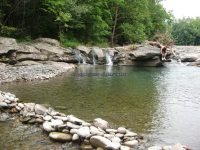
Stream, River: Kaaterskill Creek
Height, Type: Ledges
Elevation: 406 ft
Level of Difficulty, Hiking Distance: Short
Whitewater Rte, Canoe Rte Map: ————-
Maps: ————-
My Resource: Northeast Waterfalls
Book Resource: ————-
Brochures, Travel Guides, Visitor Guides: http://www.rootsweb.ancestry.com/~nygreen2/daniel_simmons.htm, Uncle Daniel Simmons from “The “Old Times Corner, First Series 1929-1930 George Halcott Chadwick editor and compiler. Mrs. Jessie Van Vechten Vedder (Greene County Historian) co-editor. Republished from The Catskill Examiner by the Greene County Historical Society at Catskill, N.Y. 1932
Trail_URL: ————-
Additional Information: ————-
Photos, Information Contributed to other Websites: ————-
Landmark: There Is A Small Bridge As Soon As You Turn Onto Drummond Falls Road.
Nearest Intersection: Hwy 32a and Drummond Falls Rd
Directions: From I-87 S in Saugerties Twn, Take exit 20 to the right onto Rt-32 towards Saugerties/Woodstock and drive for .2 miles. Turn right onto Hwy 32 and drive for 1.6 miles. Keep left onto Hwy 32 and drive for 4.2 miles. Keep left onto Hwy 32a and drive for .6 miles. Keep right onto Drummond Falls Rd for 415 ft.
Comments, Notes: There was a couple of locals here and they gave us permission to access the falls. Northeast waterfalls shows a different falls for this location, so not sure if we hiked in far enough. Or if it was actually located further downstream, in which it looked all posted.
————-
————-
————-
