
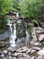
Waterfall Name: Bastion Falls
Aka: Horseshoe Falls, Bastin Falls, Sebation Falls, Rip Van Winkle Falls
Location: Hunter Twn
First Visit: 08-18-2013
State: New York State
Region: Southern Region
County: Greene County
Park Area: Lake Creek Ravine
NYS Tourism Region: Catskill Mountains
NYDEC Region: Capital Region/Northern Catskills
Waterfall Challenge: ————-
Waterfall Location: N42.19173 W74.07043
Parking: N42.18998 W74.07398
Trailhead: ————-
Trail Name, Reference to: ————-
Stream, River: Spruce Creek/Lake Creek
Height, Type: 50ft,Block Cascade
Elevation: 1534 ft
Level of Difficulty, Hiking Distance: .2 mile walk along the roadside Roadside
Whitewater Rte, Canoe Rte Map: ————-
Maps: Eastern New York all outdoors Atlas and Field Guide Publication 2008,B4,pg151
My Resource: Eastern New York all outdoors Atlas and Field Guide Publication 2008,B4,pg151
Book Resource: Catskill Region Waterfall Guide: Cool Cascades of the Catskills & Shawangunks, Paperback – September 30, 2004, by Russell Dunn, Section I: Waterfalls of the Catskills, Cloves of the Catskills-Kaaterskill Clove: Lake Creek Area,pg54
Brochures, Travel Guides, Visitor Guides: ————-
Trail_URL: http://www.catskillmountaineer.com/NSL-KF.html, Catskill Mountaineer
Additional Information: Waterfalls of New York State Paperback – August 9, 2012, by Scott Ensminger, David Schryver, Edward Smathers,Hudson Valley Region,pg56
Photos, Information Contributed to other Websites: ————-
Landmark: Trailhead Parking Palenville Overlook
Nearest Intersection: Rte 23a and Rips Lookout Rd
Directions: From I-87 S in Saugerties Twn, Take exit 20 to the right onto Rt-32 towards Saugerties/Woodstock and drive for .2 miles. Turn right onto Hwy 32 and drive for 1.6 miles. Keep left onto Hwy 32 and drive for 4.2 miles. Keep left onto Hwy 32a and drive for 5.4 miles.
Comments, Notes: This is also the beginning of the trail to kaaterskill falls. Even though this is roadside, parking is further up the road, and we had to walk quite far.
————-
————-
————-
