
Waterfall Name: Coxsackie Creek, falls on
Aka: ————-
Location: New Baltimore Twn
First Visit: 08-19-2013
State: New York State
Region: Southern Region
County: Greene County
Park Area: Detached Forest Preserve
NYS Tourism Region: Catskill Mountains
NYDEC Region: Capital Region/Northern Catskills
Waterfall Challenge: ————-
Waterfall Location: N42.38147 W73.80864
Parking: N42.38105 W73.81036
Trailhead: ————-
Trail Name, Reference to: ————-
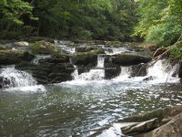
Stream, River: Coxsackie Creek
Height, Type: 3-4ft cascade upstream,downstream is 5ft,8ft cascades
Elevation: 94 ft
Level of Difficulty, Hiking Distance: .2 Miles Roundtrip
Whitewater Rte, Canoe Rte Map: ————-
Maps: ————-
My Resource: Hudson Valley Waterfall Guide: From Saratoga and the Cpaital Region to the Highlands and Palisades, Paperback – First Edition 2006, by Russell Dunn,Capital Region-Westside of the Hudson River: From Schuylerville to Catskill,pg151
Book Resource: Hudson Valley Waterfall Guide: From Saratoga and the Cpaital Region to the Highlands and Palisades, Paperback – First Edition 2006, by Russell Dunn,Capital Region-Westside of the Hudson River: From Schuylerville to Catskill,pg151
Brochures, Travel Guides, Visitor Guides: http://www.greenelandtrust.org/properties/coxsackie-creek-grassland-preserve, Green Land Trusts
Trail_URL: ————-
Additional Information: ————-
Photos, Information Contributed to other Websites: ————-
Landmark: ————-
Nearest Intersection: River Rd and East Van Gurpin Lane
Directions: From I-87 S in New Baltimore Twn, Take exit 21B to the right onto US-9w towards Rt-81/Coxsackie/Ravena and drive for .3 miles. Take the US-9w S ramp towards Rt-81/Coxsackie for 135 ft. Turn left onto US 9w and drive for 2 miles. Keep left onto Mansion St Ext and drive for 1 miles. Turn left onto Lawrence Ave and drive for 1.5 miles. Turn left onto E Van Gurpin Lane and drive for 115 ft.
Comments, Notes: There is a small pull off just past the guardrails. Follow the path down in to the creek side.
————-
————-
————-
