
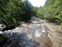
Waterfall Name: Twin Bridge Lower Falls
Aka: ————-
Location: New Breman Twn
First Visit: 09-07-2015
State: New York State
Region: Northern Region
County: Lewis County
Park Area: ————-
NYS Tourism Region: Adirondack Mountains
NYDEC Region: Western Adirondacks/Eastern Lake Ontario
Waterfall Challenge: ————-
Waterfall Location: N43.85069 W75.33747
Parking: N43.85084 W75.33723
Trailhead: ————-
Trail Name, Reference to: ————-
Stream, River: Black Creek
Height, Type: Slide
Elevation: 981 ft
Level of Difficulty, Hiking Distance: Roadside view
Whitewater Rte, Canoe Rte Map: ————-
Maps: ————-
My Resource: Northern New York Waterfalls
Book Resource: Backyard Cascades of Northern New York, 2019 by David J Schryver,Alphabetical Order,pg96
Brochures, Travel Guides, Visitor Guides: ————-
Trail_URL: ————-
Additional Information: ————-
Photos, Information Contributed to other Websites: Dig the Falls
Landmark: metal bridge with blue pipes as railings
Nearest Intersection: Beech Hill Rd and Erie Canal Rd
Directions: From the intersection of Hwy 812 and Hwy 126 and Convent Rd, Get on Convent Rd and drive east for 2.9 miles. Turn right onto Erie Canal Rd and drive 2.2 miles. The falls will be on both sides of the road.
Comments, Notes: When we were here there were some children and two young adults that stated the property was on private land and that they owned it. They did grant me permission to take a few photos, but it was hard to not include any of the folks. I did not attempt to further investagate the other side of the road as mentioned on Northern New York Waterfalls website. There were no posted signs that I had seen. I did make my apologies to the folks, and mentioned there were no posted signs. They just stated they owned it all.
————-
————-
