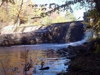
Waterfall Name: Soft Maple Reservoir Dam and Falls
Aka: ————-
Location: Croghan Twn
First Visit: 09-20-2015
State: New York State
Region: Northern Region
County: Lewis County
Park Area: ————-
NYS Tourism Region: Adirondack Mountains
NYDEC Region: Western Adirondacks/Eastern Lake Ontario
Waterfall Challenge: ————-
Waterfall Location: N43.91699 W75.22571
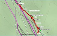
Parking: N43.91561 W75.22542
Trailhead: ————-
Trail Name, Reference to: ————-
Stream, River: Soft Maple Reservoir
Height, Type: Dam and Falls
Elevation: 1293 ft
Level of Difficulty, Hiking Distance: Easy short walk
Whitewater Rte, Canoe Rte Map: ————-
Maps: ————-
My Resource: http://www.adirondackstughill.com/maps/BeaverRiverCanoeRoute.pdf
Book Resource: ————-
Brochures, Travel Guides, Visitor Guides: ————-
Trail_URL: ————-
Additional Information: ————-
Photos, Information Contributed to other Websites: Dig the Falls
Landmark: ————-
Nearest Intersection: Beaver River Rd and Soft Maple Estate Rd
Directions: From the intersection of Hwy 126 and Hwy 812 and Covent Rd in Croghan, take Covent Rd East for .3 miles. At this point Covent Rd name changes to Kircherville Rd. Continue East on Kircherville Rd for 2.6 miles. At this point you will be at the intersection with Erie Canal Rd. Continue straight. The road name now changed to Soft Maple Rd, which is also Beaver River Rd. Continue on Soft Maple Rd for another 1.5 miles.
Comments, Notes: ————-