
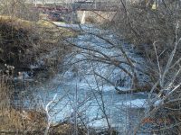
Waterfall Name: Trout Brook Falls, Le Ray Twn
Aka: ————-
Location: Le Ray Twn
First Visit: 12-15-2012
State: New York State
Region: Northern Region
County: Jefferson County
Park Area: ————-
NYS Tourism Region: Thousand Island-Seaway
NYDEC Region: Western Adirondacks/Eastern Lake Ontario
Waterfall Challenge: ————-
Waterfall Location: N44.11080 W75.78180
Parking: N44.11122 W75.78257
Trailhead: ————-
Trail Name, Reference to: ————-
Stream, River: Trout Brook
Height, Type: 20ft,Cascade
Elevation: 404 ft
Level of Difficulty, Hiking Distance: Roadside view
Whitewater Rte, Canoe Rte Map: ————-
Maps: ————-
My Resource: Northern New York Waterfalls
Book Resource: Backyard Cascades of Northern New York, 2019 by David J Schryver,Alphabetical Order,pg94
Brochures, Travel Guides, Visitor Guides: ————-
Trail_URL: ————-
Additional Information: ————-
Photos, Information Contributed to other Websites: Dig the Falls
Landmark: Private Anstead Bridge
Nearest Intersection: Elm Ridge Rd and Ansted Rd
Directions: From I-81 N in Pamelia, Take exit 48A to the right onto I-781 towards US-11/Fort Drum 4.2 miles. Take exit 4 to the right onto US-11 towards Gouverneur/Canton for .3 miles. Take the US-11 N ramp to the left for 2.2 miles. Turn left onto Main St and drive for 1.3 miles. Turn left onto Elm Ridge Rd and drive for 1.4 miles.
Comments, Notes: ————-
————-
————-
