
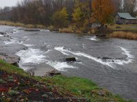
Waterfall Name: Sandy Creek Lower Falls
Aka: Belleville Falls
Location: Ellisburg Twn
First Visit: 10-28-2007
State: New York State
Region: Northern Region
County: Jefferson County
Park Area: ————-
NYS Tourism Region: Thousand Island-Seaway
NYDEC Region: Western Adirondacks/Eastern Lake Ontario
Waterfall Challenge: ————-
Waterfall Location: N43.78388 W76.11508
Parking: N43.78565 W76.11566
Trailhead: ————-
Trail Name, Reference to: ————-
Stream, River: Sandy Creek
Height, Type: Ledges Small Falls
Elevation: 445 ft
Level of Difficulty, Hiking Distance: Roadside view
Whitewater Rte, Canoe Rte Map: ————-
Maps: ————-
My Resource: New York Atlas & Gazetteer Delorme Publication 2007 Pg 83 B6 Indicated by the word falls
Book Resource: ————-
Brochures, Travel Guides, Visitor Guides: ————-
Trail_URL: ————-
Additional Information: World Waterfalls Database
Photos, Information Contributed to other Websites: Dig the Falls
Landmark: Sharps Bulk Foods
Nearest Intersection: Hwy 289 and Co Rd 75
Directions: From I-81 N in Ellisburg, Get on 40 and drive north for .2 miles. Turn left onto Hwy 193 and drive for 2.2 miles. Turn right onto Monitor Mill Rd and drive for .9 miles. Turn right onto Hwy 289 and drive for 2.7 miles. Turn right staying onto Hwy 289 and drive for .2 miles.
Comments, Notes: In 2007 we obtained permission to access from the land owners on swan road. In 2014, we stopped at sharps bulk foods to get a bite to eat and obtained permission to access from the other side.
————-
————-
