
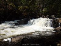
Waterfall Name: Austin Falls
Aka: ————-
Location: Wells Twn
First Visit: 05-10-2015
State: New York State
Region: Northern Region
County: Hamilton County
Park Area: ————-
NYS Tourism Region: Adirondack Mountains
NYDEC Region: Eastern Adirondacks/Lake Champlain
Waterfall Challenge: Adirondack Fifty Falls Challenge: A Guide to the Fifty Falls, by John Haywood, Russell Dunn,Hamilton,pg56
Waterfall Location: N43.50062 W74.27911
Parking: N43.49886 W74.27779
Trailhead: ————-
Trail Name, Reference to: ————-
Stream, River: Sacandaga River
Height, Type: 40ft,Chute,Flume Multi-Step,Class V
Elevation: 1502 ft
Level of Difficulty, Hiking Distance: Roadside view
Whitewater Rte, Canoe Rte Map: http://www.americanwhitewater.org/content/River/detail/id/1398
Maps: Eastern New York all outdoors Atlas and Field Guide Publication 2008,C2,pg118
My Resource: Eastern New York all outdoors Atlas and Field Guide Publication 2008,C2,pg118
Book Resource: Adirondack Waterfall Guide: New York’s Cool Cascades Paperback – September 1, 2003, by Russell Dunn,, C. Russell Dunn,I. Falls Along Route 30,pg44
Brochures, Travel Guides, Visitor Guides: ————-
Trail_URL: ————-
Additional Information: World Waterfalls Database
Photos, Information Contributed to other Websites: ————-
Landmark: Seasonal Road
Nearest Intersection: Highway 8 and Old Route 8b
Directions: From the intersection of Hwy 8 and Hwy 30 and Elm Lake Rd in Speculator, take Hwy 30 southeast for 3.2 miles. Turn left onto Old State Route 8b and drive .9 miles.
Comments, Notes: We parked here N43.49886 W74.27779 and walked the river up to the top. It was maybe a .5 mile walk along the river. We then just climbed up the bank and came back down the road to where we parked.
————-
————-

Pingback: Hamilton, Saratoga County Waterfall Trip 5-10-2015 - Bobbieswaterfalls
Pingback: Road trip to Hamilton County New York area now published 5-10-2015 | Bobbieswaterfalls