
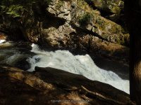
Waterfall Name: Auger Falls Lower
Aka: ————-
Location: Wells Twn
First Visit: 08-18-2008
State: New York State
Region: Northern Region
County: Hamilton County
Park Area: Siamese Ponds Wilderness
NYS Tourism Region: Adirondack Mountains
NYDEC Region: Eastern Adirondacks/Lake Champlain
Waterfall Challenge: Adirondack Fifty Falls Challenge: A Guide to the Fifty Falls, by John Haywood, Russell Dunn,Hamilton,pg54
Waterfall Location: N43.46597 W74.24773
Parking: N43.47011 W74.25202
Trailhead: N43.46761 W74.24943
Trail Name, Reference to: ————-
Stream, River: Sacandaga River
Height, Type: 100ft total,Drops
Elevation: 1261 ft
Level of Difficulty, Hiking Distance: 1.2 Mile Roundtrip
Whitewater Rte, Canoe Rte Map: http://www.americanwhitewater.org/content/River/detail/id/1398
Maps: Eastern New York all outdoors Atlas and Field Guide Publication 2008,C2,pg118
My Resource: Eastern New York all outdoors Atlas and Field Guide Publication 2008,C2,pg118
Book Resource: Adirondack Waterfall Guide: New York’s Cool Cascades Paperback – September 1, 2003, by Russell Dunn,, C. Russell Dunn,I. Falls Along Route 30,pg41
Brochures, Travel Guides, Visitor Guides: Adirondack Great Walks & Day Hikes A Guide to paths less taken in the Northeast’s last great wilderness.
Trail_URL: https://www.alltrails.com/trail/us/new-york/auger-falls-loop–2
Additional Information: World Waterfalls Database
Photos, Information Contributed to other Websites: Dig the Falls
Landmark: Registration Koisk
Nearest Intersection: Hwy 8 and Old Rte 8a
Directions: From the intersection of Hwy 8 and Hwy 30 and Elm Lake Rd in Speculator, take Hwy 30 southeast for 8 miles. From the lower parking area, walk back down towards the highway and take the trail to your left. You will come to a sign in koist. The trail is easy to follow.
Comments, Notes: There is another section of waterfalls shown on google imagery both above the location of this area which is about 330 ft further up. And below which is about .1 miles further down. I may have to go back to confirm if I did see the section above. In the photos I had grouped them as Upper, Middle and Lower. Middle being Agers Falls.
————-
————-