
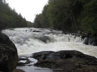
Waterfall Name: Raquette Falls
Aka: ————-
Location: Harrietstown Twn
First Visit: 05-12-2010
State: New York State
Region: Northern Region
County: Franklin County
Park Area: ————-
NYS Tourism Region: Adirondack Mountains
NYDEC Region: Eastern Adirondacks/Lake Champlain
Waterfall Challenge: ————-
Waterfall Location: N44.14504 W74.32390
Parking: N44.19989 W74.31393
Trailhead: ————-
Trail Name, Reference to: ————-
Stream, River: Raquette River
Height, Type: 10ft,Cascade Rapids
Elevation: 1600 ft
Level of Difficulty, Hiking Distance: Moderate 9 Miles Roundtrip
Whitewater Rte, Canoe Rte Map: ————-
Maps: Park Map High Peaks Region
My Resource: Eastern New York all outdoors Atlas and Field Guide Publication 2008,C1,pg102
Book Resource: Adirondack Waterfall Guide “New York’s Cool Cascades” By Russell Dunn 2004
Brochures, Travel Guides, Visitor Guides: Adirondack Great Walks & Day Hikes A Guide to paths less taken in the Northeast’s last great wilderness
Trail_URL: ————-
Additional Information: ————-
Photos, Information Contributed to other Websites: Dig the Falls, Northern New York Waterfalls
Landmark: Interior Outpost Dec
Nearest Intersection: Rte 3 Coreys Rd and Raquette Falls Trail Rd
Directions: From the intersection of Hwy and Hwy 3 in Saranac Lake, Take Hwy 3 southeast for 2.4 miles. Bear right onto Coreys Rd and drive .2 miles. Turn right onto Coreys Rd and continue 2.6 miles to Raquette Falls Parking area.
Comments, Notes: I have included the entire hike down to where the put in and take out is at the south end of the trail. So therefore I have included the falls that I had seen there. I plan to return to this location again.
————-
————-
