
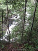
Waterfall Name: St. Huberts-Ausable River, East Branch Lower Falls
Aka: ————-
Location: Keene Twn
First Visit: 08-11-2011
State: New York State
Region: Northern Region
County: Essex County
Park Area: Adirondack Mountain Reserve
NYS Tourism Region: Adirondack Mountains
NYDEC Region: Eastern Adirondacks/Lake Champlain
Waterfall Challenge: ————-
Waterfall Location: N44.13430 W73.80980
Parking: N44.14903 W73.77027
Trailhead: N44.14972 W73.78162
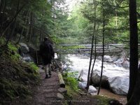
Trail Name, Reference to: East Branch Ausable River Trail
Stream, River: East Branch Ausable River
Height, Type: 10ft
Elevation: 1814 ft
Level of Difficulty, Hiking Distance: ————-
Whitewater Rte, Canoe Rte Map: ————-
Maps: ————-
My Resource: Eastern New York all outdoors Atlas and Field Guide Publication 2008,E1,pg96
Book Resource: Keene Valley Region Waterfall Guide: The Search for Cool Cascades in the Heart of the Adirondacks Paperback – November 10, 2017, by C. Russell Dunn,Section IV: Adirondack Mountain Reserve-Falls along the West River Trail,pg80
Brochures, Travel Guides, Visitor Guides: Adirondack Waterways A Guide to paddling routes in the Northeast’s last great wilderness.
Trail_URL: ————-
Additional Information: World Waterfall Database
Photos, Information Contributed to other Websites: Dig the Falls
Landmark: ————-
Nearest Intersection: St Huberts Rd and Ausable Club Rd and Lake Rd
Directions: From I-87 N in North Hudson, Take exit 30 to the right onto US-9 towards Rt-73/Keene Valley/Keene and drive for .2 miles. Turn left onto US 9 and drive for 2.2 miles. Keep left onto Hwy 73 N and drive for 5.4 miles. Turn left onto Ausable Rd and drive for .2 miles to the parking area.
Comments, Notes: ————-

————-