
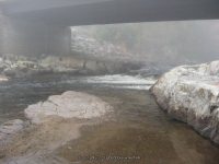
Waterfall Name: Schroon Falls
Aka: ————-
Location: Schroon Falls
First Visit: 05-23-2009
State: New York State
Region: Northern Region
County: Essex County
Park Area: ————-
NYS Tourism Region: Adirondack Mountains
NYDEC Region: Eastern Adirondacks/Lake Champlain
Waterfall Challenge: ————-
Waterfall Location: N43.89925 W73.74799
Parking: N43.90025 W73.74796
Trailhead: ————-
Trail Name, Reference to: ————-
Stream, River: Schroon River
Height, Type: 5-6ft total
Elevation: 834 ft
Level of Difficulty, Hiking Distance: Roadside view
Whitewater Rte, Canoe Rte Map: ————-
Maps: Eastern New York all outdoors Atlas and Field Guide Publication 2008,B1,pg112
My Resource: Eastern New York all outdoors Atlas and Field Guide Publication 2008,B1,pg112
Book Resource: Adirondack Waterfall Guide: New York’s Cool Cascades Paperback – September 1, 2003, by Russell Dunn,, C. Russell Dunn,III. Falls Along The Adirondack Northway, Adirondack Norway,pg179
Brochures, Travel Guides, Visitor Guides: ————-
Trail_URL: ————-
Additional Information: ————-
Photos, Information Contributed to other Websites: ————-
Landmark: DEC Camping Spot
Nearest Intersection: River Rd and Rte 9
Directions: From I-87 in Schroon Falls, Take exit 28 to the right onto Rt-74 E towards Ticonderoga-Ferry/Crown Point and drive for .3 miles. Turn right onto Nys Rte 74 and drive for 334 ft . Turn left onto US 9 and drive for 2.1 miles. Turn right onto River Rd and park near the intersection.
Comments, Notes: Walk back towards the intersection, and you will see a path on your left that leads down to the river.
————-
————-