
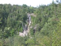
Waterfall Name: Roaring Brook Lower Falls, Keene Twn
Aka: ————-
Location: Keene Twn
First Visit: 08-10-2011
State: New York State
Region: Northern Region
County: Essex County
Park Area: ————-
NYS Tourism Region: Adirondack Mountains
NYDEC Region: Eastern Adirondacks/Lake Champlain
Waterfall Challenge: ————-
Waterfall Location: N44.15018 W73.76196
Parking: N44.15044 W73.76758
Trailhead: N44.150282 W73.7673727
Trail Name, Reference to: trailhead split for upper and lower N44.150471 W73.765173
Stream, River: Roaring Brook
Height, Type: 110ft Lower,180ft Upper (260 total) Cascade
Elevation: 1475 ft
Level of Difficulty, Hiking Distance: .8 Miles (.3 mile to the base, .5 mile to the top)
Whitewater Rte, Canoe Rte Map: ————-
Maps: National Geographic ADK Lake Placid/High Peaks Map 2004
My Resource: Eastern New York all outdoors Atlas and Field Guide Publication 2008,C1,pg104
Book Resource: Adirondack Waterfall Guide: New York’s Cool Cascades Paperback – September 1, 2003, by Russell Dunn,, C. Russell Dunn,II. Route 73,pg131
Brochures, Travel Guides, Visitor Guides: ————-
Trail_URL: ————-
Additional Information: Discover the Northeastern Adirondacks, Four-Season Adventures from Lake Champlain to the Giant of the Valley, 3rd Edition 2009, Barbara McMartin & Bill Ingersoll pg 80 trail31
Photos, Information Contributed to other Websites: ————-
Landmark: Roaring Brook Falls Trailhead
Nearest Intersection: Hwy 73 and Ausable Club Rd
Directions: From I-87 N in North Hudson, Take exit 30 to the right onto US-9 towards Rt-73/Keene Valley/Keene and drive for .2 miles. Turn left onto US 9 and drive for 2.2 miles. Keep left onto Hwy 73 N and drive for 5.3 miles. Turn right for the parking area.
Comments, Notes: ————-
————-
————-