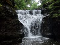
Waterfall Name: Manor Kill Falls
Aka: Stryker Falls
Location: Conesville Twn
First Visit: 08-22-2014
State: New York State
Region: Eastern Region
County: Schoharie County
Park Area: ————-
NYS Tourism Region: Central Leatherstocking
NYDEC Region: Capital Region/Northern Catskills
Waterfall Challenge: ————-
Waterfall Location: N42.38011 W74.43128
Parking: N42.38006 W74.43124
Trailhead: ————-
Trail Name, Reference to: ————-
Stream, River: Manor Kill
Height, Type: 100ft Total,Cascades Drops Plunges
Elevation: 1214 ft
Level of Difficulty, Hiking Distance: Roadside View
Whitewater Rte, Canoe Rte Map: ————-
Maps: Eastern New York all outdoors Atlas and Field Guide Publication 2008,D6,pg141
My Resource: Eastern New York all outdoors Atlas and Field Guide Publication 2008,D6,pg141
Book Resource: Mohawk Region Waterfall Guide: From the Capital District to Cooperstown & Syracuse: The Mohawak and Schoharie Valleys, Helderbergs, and Leatherstocking Country, Paperback – June 12, 2007, by Russell Dunn,Waterfalls of the Schoharie Valley,pg251
Brochures, Travel Guides, Visitor Guides: ————-
Trail_URL: ————-
Additional Information: ————-
Photos, Information Contributed to other Websites: Dig the Falls
Landmark: Gilboa Dam
Nearest Intersection: Wyckoff Rd and Prattsville Rd
Directions: From I-88 W Richmondville, Take exit 20 to the right onto Rt-7 S/Rt-10 S towards Richmondville and drive for 6.1 miles. Turn left onto Wharton Hollow Rd and drive for 5.9 miles. Turn left onto Westkill Rd and drive for 6 miles. Turn right onto Hwy 30 and drive for .4 miles. Keep left onto Hwy 30 and drive for 3.5 miles. Turn left onto St and drive forryker Rd and drive for 2.4 miles. Turn left onto Hwy 990v and drive for .9 miles. Keep right onto Hwy 990v and drive for 1 miles. Keep right onto Prattsville Rd for 502 ft.
Comments, Notes: As soon as you cross over the bridge, there is room for parking on either side of the road. The falls is located directly under the bridge. There is a fence line and a trail on the right hand side of the road. Be careful on the trail. As you head down the trail, the trail becomes a little steeper. There seemed to be several ways to get down off the trail and onto the stream bed, use caution. You will have to walk in some water to reach the base of the falls. On the opposite side of the bridge in the distance I captured another set of falls shown here.