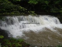
Waterfall Name: Little Schoharie Creek Lower Falls
Aka: ————-
Location: Middleburgh Twn
First Visit: 05-25-2013
State: New York State
Region: Eastern Region
County: Schoharie County
Park Area: ————-
NYS Tourism Region: Central Leatherstocking
NYDEC Region: Capital Region/Northern Catskills
Waterfall Challenge: ————-
Waterfall Location: N42.57683 W74.27312
Parking: N42.57566 W74.26960
Trailhead: ————-
Trail Name, Reference to: ————-
Stream, River: Little Schoharie Creek
Height, Type: 8ft,Drop
Elevation: 1051 ft
Level of Difficulty, Hiking Distance: .2 Miles Roundtrip
Whitewater Rte, Canoe Rte Map: ————-
Maps: ————-
My Resource: Mohawk Region Waterfall Guide “The Mohawk & Schoharie Valleys, Helderbergs, and Leatherstocking Country” By Russell Dunn
Book Resource: ————-
Brochures, Travel Guides, Visitor Guides: ————-
Trail_URL: ————-
Additional Information: http://rv52.com/rvparks/waterfalls-campsite/, Waterfalls Campsite
Photos, Information Contributed to other Websites: ————-
Landmark: waterfalls Campsite
Nearest Intersection: Huntersland Rd and Waterfall Drive
Directions: From I-88 W Schoharie Twn, Take exit 23 to the right onto Rt-30a towards Rt-7/Rt-30/Schoharie/Central Bridge and drive for .3 miles. Turn left onto Hwy 30a and drive for 8.5 miles. Turn left onto Main St and drive for 1 miles. Turn left onto Huntersland Rd for 152 ft. Bear right onto Huntersland Rd and drive for 3.2 miles. Turn right onto Waterfalls Dr for 109 ft.
Comments, Notes: The campsite owner gave us permission to go in and view the falls. She was clear on us to be careful as it was very slippery, and they were still cleaning up the damaged cause by the storm “Irene”