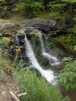
Waterfall Name: Creamery Falls
Aka: Blenheim Falls, The Falls, Haverly Falls, Mill Creek falls on (Blenheim Town)
Location: North Blenheim
First Visit: ————-
State: New York State
Region: Eastern Region
County: Schoharie County
Park Area: ————-
NYS Tourism Region: Central Leatherstocking
NYDEC Region: Capital Region/Northern Catskills
Waterfall Challenge: ————-
Waterfall Location: N42.468654 W74.460356
Parking: N42.468286 W74.460334
Trailhead: N42.468286 W74.460334
Trail Name, Reference to: ————-
Stream, River: Mill Creek
Height, Type: 10ft,20ft
Elevation: ————-
Level of Difficulty, Hiking Distance: Roadside View
Whitewater Rte, Canoe Rte Map: ————-
Maps: ————-
My Resource: Mohawk Region Waterfall Guide: From the Capital District to Cooperstown & Syracuse: The Mohawak and Schoharie Valleys, Helderbergs, and Leatherstocking Country, Paperback – June 12, 2007, by Russell Dunn,Waterfalls of the Schoharie Valley,pg243
Book Resource: ————-
Brochures, Travel Guides, Visitor Guides: ————-
Trail_URL: ————-
Additional Information: ————-
Photos, Information Contributed to other Websites: ————-
Landmark: Blenheim House
Nearest Intersection: Rte 30 and Creamery Rd
Directions: ————-
Comments, Notes: ————-