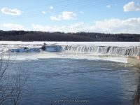
Waterfall Name: Lock 7 Dam And Falls
Aka: ————-
Location: Clifton Park Twn
First Visit: 02-22-2014
State: New York State
Region: Eastern Region
County: Schenectady County
Park Area: Goat Island
NYS Tourism Region: Capital-Saratoga
NYDEC Region: Capital Region/Northern Catskills
Waterfall Challenge: ————-
Waterfall Location: N42.80694 W73.84391
Parking: N42.80862 W73.84294
Trailhead: ————-
Trail Name, Reference to: ————-
Stream, River: Mohawk River
Height, Type: Dam and Falls
Elevation: 192 ft
Level of Difficulty, Hiking Distance: Short
Whitewater Rte, Canoe Rte Map: ————-
Maps: ————-
My Resource: Mohawk Region Waterfall Guide: From the Capital District to Cooperstown & Syracuse: The Mohawak and Schoharie Valleys, Helderbergs, and Leatherstocking Country, Paperback – June 12, 2007, by Russell Dunn,Waterfalls of the Mohawk Valley,pg40
Book Resource: Mohawk Region Waterfall Guide: From the Capital District to Cooperstown & Syracuse: The Mohawak and Schoharie Valleys, Helderbergs, and Leatherstocking Country, Paperback – June 12, 2007, by Russell Dunn,Waterfalls of the Mohawk Valley,pg40
Brochures, Travel Guides, Visitor Guides: ————-
Trail_URL: ————-
Additional Information: ————-
Photos, Information Contributed to other Websites: ————-
Landmark: Vischer Ferry Hydro Electric Plant
Nearest Intersection: Riverview Rd and Sugar Hill Rd
Directions: From I-87 N Latham, Take exit 8 to the right onto Vischer Ferry/Crescent and drive for .2 miles. Turn left onto Vischers Ferry Rd and drive for 5.2 miles.
Comments, Notes: The gate was closed, however there is a small parking area at the top. The sign states a public fishing access. We walked around the gate and went down to the bottom. There were other folks there as well.