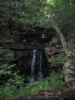
Waterfall Name: Snook Kill, Falls on
Aka: Snook Kill Falls
Location: Wilton Twn
First Visit: 07-13-2010
State: New York State
Region: Eastern Region
County: Saratoga County
Park Area: ————-
NYS Tourism Region: Capital-Saratoga
NYDEC Region: Eastern Adirondacks/Lake Champlain
Waterfall Challenge: Hudson Valley Waterfall Challenge Paperback – March 9, 2020, by John Haywood,Saratoga,pg104
Waterfall Location: N43.15242 W73.77431
Parking: N43.15318 W73.77276
Trailhead: ————-
Trail Name, Reference to: ————-
Stream, River: Snook Kill
Height, Type: 35ft,20ft,Ribbon Cascade,several drops,slides
Elevation: 633 ft
Level of Difficulty, Hiking Distance: Roadside view
Whitewater Rte, Canoe Rte Map: ————-
Maps: Eastern New York all outdoors Atlas and Field Guide Publication 2008,C1,pg128
My Resource: Adirondack Waterfall Guide: New York’s Cool Cascades Paperback – September 1, 2003, by Russell Dunn,, C. Russell Dunn,III. Falls Along The Adirondack Northway, Lake George Region,pg215
Book Resource: Waterfalls of New York State Paperback – August 9, 2012, by Scott Ensminger, David Schryver, Edward Smathers,Capital Region,pg20
Brochures, Travel Guides, Visitor Guides: ————-
Trail_URL: ————-
Additional Information: World Waterfalls Database
Photos, Information Contributed to other Websites: Dig the Falls, Northern New York Waterfalls
Landmark: ————-
Nearest Intersection: Greenfield Rd and Sankos Rd and Saratoga Rd (Rte 9)
Directions: I-87 N Malta, Take exit 15 to the right onto Rt-50 towards Saratoga Springs/Gansevoort and drive for .3 miles. Turn left onto Hwy 50 and drive for 1.1 miles. Turn right onto Marion Ave and drive for 4.1 miles. Turn left onto Parkhurst Rd and drive for .3 miles. Turn left onto Greenfield Rd and drive for .4 miles.
Comments, Notes: There is a small trail that goes to the base of the falls.