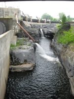
Waterfall Name: Glens Falls South
Aka: Wing Falls, Great Falls Chepontuc, Wings Falls
Location: Glens Falls
First Visit: 07-16-2010
State: New York State
Region: Eastern Region
County: Saratoga County
Park Area: Coopers Cave Bridge
NYS Tourism Region: Capital-Saratoga
NYDEC Region: Eastern Adirondacks/Lake Champlain
Waterfall Challenge: ————-
Waterfall Location: N43.30552 W73.64151
Parking: N43.30606 W73.64278
Trailhead: ————-
Trail Name, Reference to: ————-
Stream, River: Hudson River
Height, Type: 49ft,60ft,Dam and Falls
Elevation: 250 ft
Level of Difficulty, Hiking Distance: Roadside view
Whitewater Rte, Canoe Rte Map: ————-
Maps: Eastern New York All Outdoors Atlas and Field Guide Publication 2008 pg 128 A2
My Resource: Hudson Valley Waterfall Guide “From Saratoga And The Capital Region To The Highlands And Palisades” By Russell Dunn
Book Resource: Hudson Valley Waterfall Guide “From Saratoga And The Capital Region To The Highlands And Palisades” By Russell Dunn
Brochures, Travel Guides, Visitor Guides: ————-
Trail_URL: ————-
Additional Information: ————-
Photos, Information Contributed to other Websites: ————-
Landmark: Bridge For Glen Falls And South Glen Falls
Nearest Intersection: Us 9 and Mohican St and Oakland St
Directions: From I-87 S, Take exit 19 to the right onto Rt-254 towards Glens Falls/Hudson Falls and drive for .3 miles. Turn right onto Aviation Rd and drive for .7 miles. Turn right onto Glen St. and drive for 2.1 miles. Enter roundabout Centennial Cir and drive for 128 ft. Take the 2nd right onto Glen St. and drive for .2 miles.
Comments, Notes: ————-