
Waterfall Name: Moordener Kill, Falls on
Aka: Moordener Kill Upper Falls
Location: Schodack Twn
First Visit: 02-23-2014
State: New York State
Region: Eastern Region
County: Rensselaer County
Park Area: ————-
NYS Tourism Region: Capital-Saratoga
NYDEC Region: Capital Region/Northern Catskills
Waterfall Challenge: ————-
Waterfall Location: N42.53428 W73.73476
Parking: N42.5344655 W73.734346
Trailhead: ————-
Trail Name, Reference to: ————-
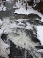
Stream, River: Moordener Kill
Height, Type: 10ft,5ft Cascade
Elevation: 155 ft – 147 ft
Level of Difficulty, Hiking Distance: Roadside Views
Whitewater Rte, Canoe Rte Map: ————-
Maps: ————-
My Resource: Hudson Valley Waterfall Guide: From Saratoga and the Cpaital Region to the Highlands and Palisades, Paperback – First Edition 2006, by Russell Dunn,Capital Region-Eastside of the Hudson River: From Dionondahowa Falls to the City of Hudson,pg111
Book Resource: Hudson Valley Waterfall Guide: From Saratoga and the Cpaital Region to the Highlands and Palisades, Paperback – First Edition 2006, by Russell Dunn,Capital Region-Eastside of the Hudson River: From Dionondahowa Falls to the City of Hudson,pg111
Brochures, Travel Guides, Visitor Guides: ————-
Trail_URL: ————-
Additional Information: ————-
Photos, Information Contributed to other Websites: Dig the Falls
Landmark: Directly Under The Bridge
Nearest Intersection: Hwy 150 and Seaman Ave and Maple Hill Rd
Directions: From I-90 W near Shodack Twn, Take exit 11 onto US-9/US-20 towards E Greenbush/Nassau for 188 ft. Exit right onto ramp onto Columbia Tpke and drive for .3 miles. Turn right onto Columbia Tpke and drive for .3 miles. Turn right onto Schodack Valley Rd and drive for 2 miles. Turn left onto Brookview Rd and drive for 1.8 miles.
Comments, Notes: Dam N42.53435 W73.73420/Falls N42.534379 W73.734647/Falls N42.533985 W73.737824
Pingback: Road Trip to Rensselaer County, New York area 2/23/2014 Day 2 - Bobbieswaterfalls