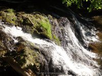
Waterfall Name: Burden Falls, Falls Below Dam
Aka: Rail Joint Mill Dam
Location: South Troy
First Visit: 05-14-2015
State: New York State
Region: Eastern Region
County: Rensselaer County
Park Area: Burden Falls Environmental Park
NYS Tourism Region: Capital-Saratoga
NYDEC Region: Capital Region/Northern Catskills
Waterfall Challenge: Hudson Valley Waterfall Challenge Paperback – March 9, 2020, by John Haywood,Rensselear,pg92
Waterfall Location: N42.704166 W73.693674
Parking: N42.70447 W73.69336
Trailhead: ————-
Trail Name, Reference to: ————-
Stream, River: Wynants Kill
Height, Type: Dam and Falls
Elevation: 99 ft – 75 ft
Level of Difficulty, Hiking Distance: Short Scramble Down A Steep Bank
Whitewater Rte, Canoe Rte Map: ————-
Maps: ————-
My Resource: Hudson Valley Waterfall Guide: From Saratoga and the Cpaital Region to the Highlands and Palisades, Paperback – First Edition 2006, by Russell Dunn,Capital Region-Eastside of the Hudson River: From Dionondahowa Falls to the City of Hudson,pg87
Book Resource: Hudson Valley Waterfall Guide: From Saratoga and the Cpaital Region to the Highlands and Palisades, Paperback – First Edition 2006, by Russell Dunn,Capital Region-Eastside of the Hudson River: From Dionondahowa Falls to the City of Hudson,pg87
Brochures, Travel Guides, Visitor Guides: ————-
Trail_URL: Natural Areas of Rensselaer County, NY
Additional Information: http://www.nyfalls.com/board/viewtopic.php?f=1&t=4713
Photos, Information Contributed to other Websites: ————-
Landmark: ————-
Nearest Intersection: Us 4 and Snyder Ave
Directions: The directions provided here will get you to each of the locations for the waterfalls in this area, considered for the Burden Environmental Park Waterfalls.From I-787 N near Menands, Take exit 7E to the right onto Rt-378 E towards South Troy and drive for 1.1 miles. Turn left onto Kelly St for 237 ft. Turn left onto Cross St for 373 ft. Turn right onto Burden Ave for 337 ft. Keep right onto Water St for 74 ft. Wynants Kill falls on (Near Water St) Parking Perform a U-Turn back onto Water St for 63 ft. Turn right onto Mill St and drive for .2 miles. Wynants Kill Dam And Falls Below Burden Falls Parking for 33 ft. Get on Mill St and drive east and drive for .3 miles. Turn left onto Campbell Ave for 230 ft. Turn right onto Willis St for 35 ft. Burden Falls (on Wynants Kill) Parking Get on Willis St and drive north for 32 ft. Turn right onto Campbell Ave and drive for .6 miles. Wynants Kill Burden Parking
Comments, Notes: This dam and waterfall is located further downstream from burden falls. You can see whats left of a stone wall, use caution when trying to go further downstream to view the falls from below.