
Waterfall Name: Wilsey Creek falls on
Aka: ————-
Location: Charleston Twn
First Visit: 05-30-2016
State: New York State
Region: Eastern Region
County: Montgomery County
Park Area: ————-
NYS Tourism Region: Central Leatherstocking
NYDEC Region: Capital Region/Northern Catskills
Waterfall Challenge: ————-
Waterfall Location: N42.82033 W74.31376
Parking: N42.82033 W74.31376
Trailhead: ————-
Trail Name, Reference to: ————-
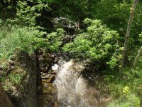
Stream, River: Wilsey Creek
Height, Type: Falls Both sides of the road,Various
Elevation: 1090 ft
Level of Difficulty, Hiking Distance: Roadside views
Whitewater Rte, Canoe Rte Map: ————-
Maps: ————-
My Resource: Drive By
Book Resource: ————-
Brochures, Travel Guides, Visitor Guides: ————-
Trail_URL: ————-
Additional Information: ————-
Photos, Information Contributed to other Websites: Dig the Falls
Landmark: Stone bridge
Nearest Intersection: Burtonville Rd and Goewey Rd
Directions: From I-90 E, near Rotterdam, Take exit 25A to the right onto I-88 towards Rt-7/Schenectady/Binghamton and drive for 0.7 miles. Continue on I-88 W towards Binghamton and drive for 4.7 miles. Take exit 24 to the right towards US-20/Rt-7/Duanesburg and drive for 0.2 miles. Take ramp to the right towards Rt-7/Duanesburg/Schenectady and drive for 0.1 miles. Turn left onto Hwy 7 and drive for 1.0 miles. Keep right onto Western Tpke and drive for 3.5 miles. Turn right onto McGuire School Rd and drive for 2.4 miles. Keep left onto Eaton Corners Rd and drive for 1.7 miles. Turn left onto Bramans Corners Rd and drive for 0.7 miles. Turn right onto Burtonville Rd and drive for 3.5 miles.
Comments, Notes: I have put this on my list to visit again in the spring or fall season as viewing was very hard to really see what was down in there. The land is posted!
Map_URL: