
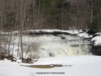
Waterfall Name: Timmerman Creek, Falls on #02
Aka: ————-
Location: Saint Johnsville Twn
First Visit: 03-17-2011
State: New York State
Region: Eastern Region
County: Montgomery County
Park Area: ————-
NYS Tourism Region: Central Leatherstocking
NYDEC Region: Capital Region/Northern Catskills
Waterfall Challenge: ————-
Waterfall Location: N43.02037 W74.68216
Parking: N43.01948 W74.68350
Trailhead: ————-
Trail Name, Reference to: ————-
Stream, River: Timmerman Creek
Height, Type: ————-
Elevation: 721 ft
Level of Difficulty, Hiking Distance: Roadside views
Whitewater Rte, Canoe Rte Map: ————-
Maps: ————-
My Resource: Mohawk Region Waterfall Guide: From the Capital District to Cooperstown & Syracuse: The Mohawak and Schoharie Valleys, Helderbergs, and Leatherstocking Country, Paperback – June 12, 2007, by Russell Dunn,Waterfalls of the Mohawk Valley,pg109
Book Resource: Mohawk Region Waterfall Guide: From the Capital District to Cooperstown & Syracuse: The Mohawak and Schoharie Valleys, Helderbergs, and Leatherstocking Country, Paperback – June 12, 2007, by Russell Dunn,Waterfalls of the Mohawk Valley,pg109
Brochures, Travel Guides, Visitor Guides: ————-
Trail_URL: ————-
Additional Information: ————-
Photos, Information Contributed to other Websites: Dig the Falls, Northern New York Waterfalls
Landmark: Private
Nearest Intersection: Crum Creek and Mill Rd
Directions: From I-90 W, at Indian Castle, Take exit 29A to the right onto Rt-169 towards Little Falls/Dolgeville and drive for 2.7 miles. Turn right onto Hwy 167 E and drive for 8.3 miles. Turn left onto Mill Rd and drive for 1.7 miles.
Comments, Notes: Can be seen right from the intersection going north. Roadside
Map_URL: