
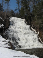
Waterfall Name: Scudders Falls
Aka: Zimmerman Falls
Location: Saint Johnsville Twn
First Visit: 03-17-2011
State: New York State
Region: Eastern Region
County: Montgomery County
Park Area: ————-
NYS Tourism Region: Central Leatherstocking
NYDEC Region: Capital Region/Northern Catskills
Waterfall Challenge: ————-
Waterfall Location: N43.01380 W74.67167
Parking: N43.01453 W74.67197
Trailhead: ————-
Trail Name, Reference to: ————-
Stream, River: Zimmerman Creek
Height, Type: 50ft,Pagoda Shaped
Elevation: 603 ft
Level of Difficulty, Hiking Distance: Roadside views
Whitewater Rte, Canoe Rte Map: ————-
Maps: ————-
My Resource: Mohawk Region Waterfall Guide: From the Capital District to Cooperstown & Syracuse: The Mohawak and Schoharie Valleys, Helderbergs, and Leatherstocking Country, Paperback – June 12, 2007, by Russell Dunn,Waterfalls of the Mohawk Valley,pg103
Book Resource: Mohawk Region Waterfall Guide: From the Capital District to Cooperstown & Syracuse: The Mohawak and Schoharie Valleys, Helderbergs, and Leatherstocking Country, Paperback – June 12, 2007, by Russell Dunn,Waterfalls of the Mohawk Valley,pg103
Brochures, Travel Guides, Visitor Guides: Zimmerman Creek “Three Rivers”
Trail_URL: ————-
Additional Information: ————-
Photos, Information Contributed to other Websites: Dig the Falls, Northern New York Waterfalls
Landmark: Water Treatment Plant
Nearest Intersection: Lasselville Rd and Crum Creek Rd (North Division St.)
Directions: From I-90 W, at Indian Castle, Take exit 29A to the right onto Rt-169 towards Little Falls/Dolgeville and drive for 2.7 miles. Turn right onto Hwy 167 E and drive for 9.3 miles. Turn left onto N Division St and drive for .8 miles. Keep right onto Lasselville Rd and drive for .4 miles.
Comments, Notes: This is now posted call, the village of St Johnsville for permission.
Map_URL: