
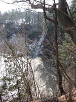
Waterfall Name: Cemetery Falls
Aka: Cemetery Falls (Tributary to Canajoharie Creek)
Location: Canajoharie Twn
First Visit: 03-17-2011
State: New York State
Region: Eastern Region
County: Montgomery County
Park Area: ————-
NYS Tourism Region: Central Leatherstocking
NYDEC Region: Capital Region/Northern Catskills
Waterfall Challenge: ————-
Waterfall Location: N42.89588 W74.56919
Parking: N42.89563 W74.57252
Trailhead: ————-
Trail Name, Reference to: ————-
Stream, River: Canajoharie Creek, Tributary to
Height, Type: 40ft,Cascade
Elevation: 410 ft
Level of Difficulty, Hiking Distance: Short Walk Or Drive
Whitewater Rte, Canoe Rte Map: ————-
Maps: ————-
My Resource: Mohawk Region Waterfall Guide: From the Capital District to Cooperstown & Syracuse: The Mohawak and Schoharie Valleys, Helderbergs, and Leatherstocking Country, Paperback – June 12, 2007, by Russell Dunn,Waterfalls of the Mohawk Valley,pg98
Book Resource: Mohawk Region Waterfall Guide: From the Capital District to Cooperstown & Syracuse: The Mohawak and Schoharie Valleys, Helderbergs, and Leatherstocking Country, Paperback – June 12, 2007, by Russell Dunn,Waterfalls of the Mohawk Valley,pg98
Brochures, Travel Guides, Visitor Guides: ————-
Trail_URL: ————-
Additional Information: Waterfalls of New York State Paperback – August 9, 2012, by Scott Ensminger, David Schryver, Edward Smathers,Capital Region,pg28
Photos, Information Contributed to other Websites: Dig the Falls
Landmark: Prospect Hill Cemetery
Nearest Intersection: Highway 10 and Hickory Grove Rd
Directions: From I-90 W in Canajoharie, Take exit 29 to the right towards Rt-10/Canajoharie/Sharon Springs and drive for .7 miles. Turn right onto E Main St and drive for .2 miles. Turn left onto Church St for 485 ft. Turn right onto Cliff St and drive for .1 miles. Turn left onto Walnut St and drive for .8 miles.
Comments, Notes: Go to the back eastern part of the cemetery. Look for the Spraker family plot, and go behind that.
Map_URL: