

Waterfall Name: Fall Creek, Rocky Falls
Aka: Sibley Falls
Location: Ithaca
First Visit: 05-24-2008
State: New York State
Region: Central Region
County: Tompkins County
Park Area: Fall Creek Gorge
NYS Tourism Region: Finger Lakes-Wine Country
NYDEC Region: Central New York
Waterfall Challenge:Finger Lakes Region Waterfall Challenge Paperback – October 30, 2019, by John Haywood, Julie Hughes Romano, Bella Romano, Edward Smathers,Tompkins,pg86
Waterfall Location: N42.4520738 W76.4845427
Parking: N42.45158 W76.49093
Trailhead: N42.45203 W76.48970
Trail Name, Reference to: Information koist for Forest, Horseshoe, Rocky Falls N42.45203 W76.48970 654 ft, Fall Creek Dr Parking N42.4523984 W76.485343 743 ft, University Ave Parking and Trail N42.45141 W76.48500 725 ft
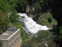
Stream, River: Falls Creek
Height, Type: 25ft Cascade
Elevation: 691 ft
Level of Difficulty, Hiking Distance: Approx 2 Mile Rt/W for 4 Falls
Whitewater Rte, Canoe Rte Map: ————-
Maps: Western New York All-Outdoors Atlas & Field Guide, 2008,B6,pg103
My Resource: Western New York All-Outdoors Atlas & Field Guide, 2008,B6,pg103
Book Resource: 200 Waterfalls in Central and Western New York: A Finder’s Guide Paperback – June 5, 2018, by Rich and Sue Freeman,Waterfalls in Schuyler and Tompkins Counties,pg244
Brochures, Travel Guides, Visitor Guides: Rocky Falls Looking up at from pedestrian bridge N42.45183 W76.48610 746 ft,
Trail_URL: ————-
Additional Information: New York Waterfalls “A Guide For Hikers & Photographers” by Scott E. Brown 2010
Photos, Information Contributed to other Websites: Dig the Falls
Landmark: Cornell University Campus
Nearest Intersection: Stewart Ave and Willard Way
Directions: I-81 South in Cortland, Take exit 12 to the right onto US-11/Rt-41 towards Rt-281/Homer/Cortland and drive for .4 miles. Keep left onto Hwy 281 ramp and drive for .5 miles. Take the Rt-281 S ramp towards Ithaca for 196 ft. Turn left onto Hwy 281 and drive for 11.4 miles. Turn right onto W Main St and drive for 6.0 miles. Turn left onto Dryden Rd and drive for 3.3 miles. Turn right onto Tower Rd for 431 ft. Turn left onto Campus Rd and drive for 1.3 miles. Turn right onto Stewart Ave and drive for .5 miles.
Comments, Notes: We had followed a path that went along creek up to the base of Triphammer Falls.
————-
————-
Pingback: Forest, Foaming, Rocky and Horseshoe Falls - Bobbieswaterfalls
Pingback: Cayuga Heights - Fall Creek, Forest Falls, Foaming Falls, Horseshoe and Rocky Falls - Bobbieswaterfalls