
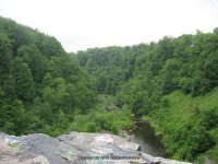
Waterfall Name: Salmon River Falls
Aka: ————-
Location: Orwell Twn
First Visit: 06-27-2004
State: New York State
Region: Central Region
County: Oswego County
Park Area: Salmon River Falls State Park, Salmon River Unique Area
NYS Tourism Region: Thousand Island-Seaway
NYDEC Region: Central New York
Waterfall Challenge:————-
Waterfall Location: N43.54773 W75.94047
Parking: N43.54929 W75.94259
Trailhead: ————-
Trail Name, Reference to: ————-
Stream, River: Salmon River
Height, Type: 110ft,Block
Elevation: 825 ft
Level of Difficulty, Hiking Distance: Easy to Difficult .4 Mile Round Trip There is a steep trail that takes you to the bottom of the falls.
Whitewater Rte, Canoe Rte Map: ————-
Maps: Western New York All-Outdoors Atlas & Field Guide, 2008,C1,pg156
My Resource: Western New York all outdoors Atlas & Field Guide Publication 2008 Pg 156 D1
Book Resource: ————-
Brochures, Travel Guides, Visitor Guides: Falls Unique Area Unit Management Plan
Trail_URL: ————-
Additional Information: Salmon River Corridor/Watershed
Photos, Information Contributed to other Websites: Dig the Falls
Landmark: Salmon River Unique Area
Nearest Intersection: Falls Rd and Dam Rd
Directions: From Richland, at the intersection of Main St (County Route 48) and County Route 2, take County Route 2 east for 2.9 miles. You will come to the small town of Orwell. At the intersection take a right onto County Route 22. Drive 2.7 miles on County Route 22. At 2.7 miles turn left onto falls road and drive 1.5 miles to the parking area on your right.
Comments, Notes: ————-
————-
————-
————-

Pingback: Waterfalls of New York State 100+ Challenge, Dig the Falls, part 5, The North Country Region - Bobbieswaterfalls
Pingback: THE FOLLOWING LOCATIONS ARE NOW PUBLISHED 3/11/2015 | Bobbieswaterfalls