
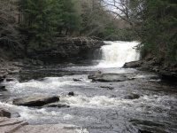
Waterfall Name: Mad River Falls
Aka: ————-
Location: Redfield Twn
First Visit: 10-24-2007
State: New York State
Region: Central Region
County: Oswego County
Park Area: Battle Hill State Forest
NYS Tourism Region: Thousand Island-Seaway
NYDEC Region: Central New York
Waterfall Challenge:————-
Waterfall Location: N43.59378 W75.81732
Parking: N43.59838 W75.81871
Trailhead: ————-
Trail Name, Reference to: Public Fishing Rights Maps Mad River and Tributaries
Stream, River: Mad River
Height, Type: 20ft,Ledge Drop Cascade
Elevation: 1200 ft
Level of Difficulty, Hiking Distance: Easy To Moderate .3 Miles Down Stream From The Bridge Public Fishing Access
Whitewater Rte, Canoe Rte Map: ————-
Maps: Western New York all outdoors Atlas & Field Guide Publication 2008 Pg 156 C2
My Resource: Friends
Book Resource: ————-
Brochures, Travel Guides, Visitor Guides: ————-
Trail_URL: Battle Hill State Forest Map
Additional Information: History of State Forests in Region 7
Photos, Information Contributed to other Websites: Dig the Falls,Northern New York Waterfalls
Landmark: Iron Bridge “leo F. Nemier Mad River Bridge”
Nearest Intersection: Otto Mills Rd and Route 17
Directions: From I-81 S, in Pulaski, Take exit 37 to the right towards Sandy Creek/Lacona and drive for .2 miles. Turn left onto Salisbury St and drive for .8 miles. Turn right onto Ridge Rd and drive for .3 miles. Turn left onto Smartville Rd and drive for 8.6 miles. Turn right onto Cr-17 and drive for 5.0 miles. Turn left onto Otto Mills Drive and drive for 1.5 miles. There is room for a few cars to park on the left without blocking access to camp owners.
Comments, Notes: To see Mad River Falls and Middle Falls from parking as you head towards river there is a dirt road to your right, follow that all the way. Please be curtious of camp owners. I had received permissions from the camp owners. So far access has not been stopped. Private property
————-
————-
————-