
Waterfall Name: Jamesville Quarry Dam
Aka: ————-
Location: De Witt Twn
First Visit: 04-05-2015
State: New York State
Region: Central Region
County: Onondaga County
Park Area: ————-
NYS Tourism Region: Finger Lakes-Wine Country
NYDEC Region: Central New York
Waterfall Challenge:————-
Waterfall Location: N43.00555 W76.07523
Parking: N43.00590 W76.07517
Trailhead: ————-
Trail Name, Reference to: ————-
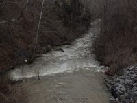
Stream, River: Butternut Creek
Height, Type: Dam
Elevation: 481 ft
Level of Difficulty, Hiking Distance: Roadside view
Whitewater Rte, Canoe Rte Map: ————-
Maps: ————-
My Resource: Google Imagery
Book Resource: ————-
Brochures, Travel Guides, Visitor Guides: ————-
Trail_URL: ————-
Additional Information: ————-
Photos, Information Contributed to other Websites: Dig the Falls
Landmark: Jamesville Rock Quarry
Nearest Intersection: North St and Jamesville Rd and Jamesville Toll Rd
Directions: From I-481 N, in De Witt, Take exit 2 to the right onto Jamesville Rd towards Jamesville and drive .3 miles. Turn right onto Jamesville Rd and drive for .4 miles.
Comments, Notes: Google imagery showed possible falls in this location on both sides of the highway but this dam was what I found. It maybe possible there is but the water level was very high.
————-
————-
————-
