
Waterfall Name: Coye Road Falls
Aka: ————-
Location: Lafayette Twn
First Visit: 04-29-2015
State: New York State
Region: Central Region
County: Onondaga County
Park Area: ————-
NYS Tourism Region: Finger Lakes-Wine Country
NYDEC Region: Central New York
Waterfall Challenge:————-
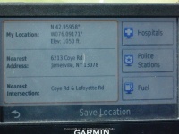
Waterfall Location: N42.95958 W76.09150
Parking: N42.95958 W76.09150
Trailhead: ————-
Trail Name, Reference to: ————-
Stream, River: Rush Creek
Height, Type: ————-
Elevation: 1050 ft
Level of Difficulty, Hiking Distance: Roadside View
Whitewater Rte, Canoe Rte Map: ————-
Maps: ————-
My Resource: World Waterfalls Database
Book Resource: ————-
Brochures, Travel Guides, Visitor Guides: ————-
Trail_URL: ————-
Additional Information: ————-
Photos, Information Contributed to other Websites: Dig the Falls
Landmark: ————-
Nearest Intersection: Old Coye Rd and 144 Coye Rd
Directions: From I-81 N, South of Nedrow, Take exit 16 to the right onto US-11 towards Onondaga Nation Territory for .2 miles. Turn left onto US 11 and drive for .2 miles. Turn right onto Kennedy Rd 337 ft. Turn left onto Kennedy Rd and drive for .9 miles. Turn right onto Sentinel Heights Rd and drive for .6 miles. Turn left onto Dave Tilden Rd and drive for .4 miles. Turn right onto Lafayette Rd and drive for 2.0 miles. Turn left onto Old Coye Rd and drive for .2 miles. Turn left onto Coye Rd for 344 ft. The falls are almost directly under the road.
Comments, Notes: This is on private property. There is not much to see from the roadside. Permission would have to be obtained from the land owner.
————-
————-
————-

Pingback: Roadtrip on 4-29-2015 to Onondaga County Area - Bobbieswaterfalls