
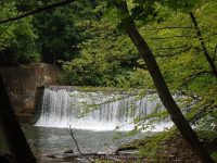
Waterfall Name: Sherrill Dam
Aka: ————-
Location: Sherrill
First Visit: 08-31-2014
State: New York State
Region: Central Region
County: Oneida County
Park Area: ————-
NYS Tourism Region: Central Leatherstocking
NYDEC Region: Western Adirondacks/Eastern Lake Ontario
Waterfall Challenge:————-
Waterfall Location: N43.07983 W75.59348
Parking: N43.08023 W75.59323
Trailhead: ————-
Trail Name, Reference to: ————-
Stream, River: Sconondoa Creek
Height, Type: Dam
Elevation: 505 ft
Level of Difficulty, Hiking Distance: Roadside views
Whitewater Rte, Canoe Rte Map: ————-
Maps: ————-
My Resource: ————-
Book Resource: ————-
Brochures, Travel Guides, Visitor Guides: ————-
Trail_URL: ————-
Additional Information: ————-
Photos, Information Contributed to other Websites: ————-
Landmark: Department Public Works Hwy
Nearest Intersection: Stone St and Elmwood Pl
Directions: From I-90 W, in Verona, Take exit 33 to the right onto Rt-365 towards Verona/Oneida and drive for .9 miles. Keep left onto Rd ramp and drive for .2 miles. Turn left onto Hwy 365 W and drive for .5 miles. Turn left onto Patrick Rd and drive for 1.0 miles. Turn right onto Beacon Light Rd and drive for 1.8 miles. Turn right onto Pexton St and drive for .2 miles. Turn right onto Elmwood Place and drive for .1 miles.
Comments, Notes: ————-
————-
————-
————-
