
Waterfall Name: Lansing Kill Falls
Aka: ————-
Location: Boonville Twn
First Visit: 10-18-2014
State: New York State
Region: Central Region
County: Oneida County
Park Area: ————-
NYS Tourism Region: Central Leatherstocking
NYDEC Region: Western Adirondacks/Eastern Lake Ontario
Waterfall Challenge:————-
Waterfall Location: N43.43409 W75.32684
Parking: N43.43334 W75.32817
Trailhead: ————-
Trail Name, Reference to: ————-
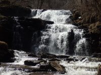
Stream, River: Lansing Kill Creek
Height, Type: 35ft approx
Elevation: 1020 ft
Level of Difficulty, Hiking Distance: Short Scramble
Whitewater Rte, Canoe Rte Map: ————-
Maps: ————-
My Resource: World Waterfall Database
Book Resource: ————-
Brochures, Travel Guides, Visitor Guides: ————-
Trail_URL: ————-
Additional Information: ————-
Photos, Information Contributed to other Websites: Dig the Falls
Landmark: Parking area for the Erie Canal Trail
Nearest Intersection: Rte 46 and Holmes Rd
Directions: From I-90 W, in Westmoreland, Take exit 32 to the right towards Rt-233/Westmoreland/Rome and drive for .7 miles. Turn right onto Cider St and drive for .1 miles. Turn right onto Hwy 233 and drive for 5.7 miles. Take the Rt-49 W/Rt-69 W/Rt-365 W ramp to the left and drive for .4 miles. Take the Rt-49 W/Rt-69 W ramp to the right towards Rt-26 N/Rt-46/Downtown Rome and drive for 1.3 miles. Keep right onto Rd and drive for 3.3 miles. Keep right onto Rome Westernville Rd and drive for 17.5 miles.
Comments, Notes: There is a small parking spot almost directly in front of an access point for the canal trail system. You will see the bridge and falls from the road. From the road you will go le Ft and cross the bridge. The well worn path down is directly to your right. The trail gets steep and was very muddy and slippery. The trail is not maintained. There was no posted signs that we could see. The trail is short and you will look for another trail on your right that goes down to the bottom between the two waterfalls. If I have this correctly the waterfall you see from the bridge looking down is Lansing Kill Falls. The waterfall you see in the distance is Bakers Falls. Lansing Kill Falls is fed by the Lansing Kill River. Bakers Falls is fed by the Lansing Kill Creek. They both meet at the bottom and continue the flow into Lansing Kill River.
————-
————-
————-
