
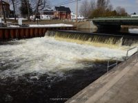
Waterfall Name: Camden Dam and Falls #2
Aka: ————-
Location: Camden
First Visit: 03-31-2009
State: New York State
Region: Central Region
County: Oneida County
Park Area: ————-
NYS Tourism Region: Central Leatherstocking
NYDEC Region: Western Adirondacks/Eastern Lake Ontario
Waterfall Challenge:————-
Waterfall Location: N43.33424 W75.74893
Parking: N43.33446 W75.74851
Trailhead: ————-
Trail Name, Reference to: ————-
Stream, River: West Branch Fish Creek
Height, Type: Dam
Elevation: 505 ft
Level of Difficulty, Hiking Distance: Roadside views
Whitewater Rte, Canoe Rte Map: ————-
Maps: ————-
My Resource: Camden New York Historical Society
Book Resource: ————-
Brochures, Travel Guides, Visitor Guides: ————-
Trail_URL: ————-
Additional Information: ————-
Photos, Information Contributed to other Websites: Dig the Falls
Landmark: Behind Jreck Subs
Nearest Intersection: Mexico St and Main St
Directions: From I-90 W, in Westmoreland, Take exit 32 to the right towards Rt-233/Westmoreland/Rome and drive for .7 miles. Turn right onto Cider St and drive for .1 miles. Turn right onto Hwy 233 and drive for 5.7 miles. Take the Rt-49 W/Rt-69 W/Rt-365 W ramp to the left and drive for .4 miles. Take the Rt-49 W/Rt-69 W ramp to the right towards Rt-26 N/Rt-46/Downtown Rome and drive for 1.3 miles. Keep left onto Erie Blvd E and drive for 18 miles. Turn left onto Hwy 13 and drive for .2 miles.
Comments, Notes: From the main stop light you turn right onto Mexico Street there is a parking lot on either side of the road you can also cross the bridge and see this from the little memorial park
————-
————-
————-
