
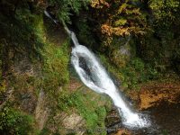
Waterfall Name: Button Falls
Aka: ————-
Location: Brookfield Twn
First Visit: 04-03-2008
State: New York State
Region: Central Region
County: Madison County
Park Area: ————-
NYS Tourism Region: Central Leatherstocking
NYDEC Region: Central New York
Waterfall Challenge:————-
Waterfall Location: N42.78992 W75.26831
Parking: N42.79160 W75.26912
Trailhead: ————-
Trail Name, Reference to: ————-
Stream, River: Button Creek
Height, Type: 8ft,40ft,Cascade
Elevation: 1212 ft
Level of Difficulty, Hiking Distance: Roadside views
Whitewater Rte, Canoe Rte Map: ————-
Maps: Delorme Atlas & Gazetteer New York State 9th Edition 2011
My Resource: Eastern New York all outdoors Atlas and Field Guide Publication 2008,C4,pg131
Book Resource: Mohawk Region Waterfall Guide: From the Capital District to Cooperstown & Syracuse: The Mohawak and Schoharie Valleys, Helderbergs, and Leatherstocking Country, Paperback – June 12, 2007, by Russell Dunn,Waterfalls Along Route 20,pg155
Brochures, Travel Guides, Visitor Guides: ————-
Trail_URL: ————-
Additional Information: 200 Waterfalls in Central and Western New York: A Finder’s Guide Paperback – June 5, 2018, by Rich and Sue Freeman,Waterfalls in Onondaga, Madison and Oneida Counties,pg351
Photos, Information Contributed to other Websites: Dig the Falls
Landmark: ————-
Nearest Intersection: Button Falls Rd and Burch Rd
Directions: From I-90 W, in Herkimer, Take exit 30 to the right onto Rt-28 towards Herkimer/Mohawk and drive for .6 miles. Turn left onto Mohawk St and drive for .1 miles. Keep right onto Hwy 5s W and drive for .5 miles. Turn left onto Warren St and drive for 1.6 miles. Turn right onto Ward Rd and drive for .7 miles. Turn left onto Warren Rd and drive for 4.3 miles. Turn left onto Elizabethtown Rd and drive for 6.3 miles. Turn right onto US 20 and drive for 2.8 miles. Turn left onto South St and drive for 1.6 miles. Turn right onto Forks Rd and drive for 3.7 miles. Turn left onto Hwy 8 and drive for 3.8 miles. Turn right onto Button Falls Rd and drive for .5 miles.
Comments, Notes: When we returned here there is a trail on the right side of the creek. Land status unknown at this time.
————-
————-
————-
