
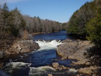
Waterfall Name: Wilmurt Falls
Aka: High Falls
Location: Ohio Twn
First Visit: 05-02-2015
State: New York State
Region: Central Region
County: Herkimer County
Park Area: ————-
NYS Tourism Region: Adirondack Mountains
NYDEC Region: Western Adirondacks/Eastern Lake Ontario
Waterfall Challenge:————-
Waterfall Location: N43.37496 W74.90489
Parking: N43.37430 W74.90481
Trailhead: ————-
Trail Name, Reference to: ————-
Stream, River: West Canada Creek
Height, Type: 6ft
Elevation: 1359 ft
Level of Difficulty, Hiking Distance: Roadside views
Whitewater Rte, Canoe Rte Map: ————-
Maps: ————-
My Resource: World Waterfall Database
Book Resource: ————-
Brochures, Travel Guides, Visitor Guides: ————-
Trail_URL: ————-
Additional Information: ————-
Photos, Information Contributed to other Websites: Dig the Falls
Landmark: ————-
Nearest Intersection: Gray-Wilmurt Rd and Hwy 8
Directions: From I-90 W, at Indian Castle, Take exit 29A to the right onto Rt-169 towards Little Falls/Dolgeville and drive for 2.7 miles.Turn left onto Hwy 167 W and drive for .2 miles. Turn right onto E Main St and drive for .3 miles. Turn right onto Salisbury St and drive for .2 miles. Turn right onto E Monroe St and drive for 6.9 miles. Turn left onto Hwy 29 and drive for .7 miles. Turn right onto Hard Scrabble Rd and drive for 6.2 miles. Turn right onto Newport-Gray Rd and drive for 13.0 miles. Turn right onto Jones Rd and park anywhere along the road.
Comments, Notes: The land around this is posted
————-
————-
————-
