
Waterfall Name: Diamond Hill Lower Falls
Aka: ————-
Location: Salisbury Twn
First Visit: 01-13-2013
State: New York State
Region: Central Region
County: Herkimer County
Park Area: ————-
NYS Tourism Region: Adirondack Mountains
NYDEC Region: Western Adirondacks/Eastern Lake Ontario
Waterfall Challenge:————-
Waterfall Location: N43.15521 W74.84371
Parking: N43.15601 W74.84534
Trailhead: ————-
Trail Name, Reference to: ————-
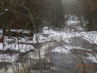
Stream, River: Spruce Creek
Height, Type: 15ft,Cascade
Elevation: 1210 ft
Level of Difficulty, Hiking Distance: Roadside views
Whitewater Rte, Canoe Rte Map: ————-
Maps: ————-
My Resource: World Waterfall Database
Book Resource: ————-
Brochures, Travel Guides, Visitor Guides: ————-
Trail_URL: ————-
Additional Information: ————-
Photos, Information Contributed to other Websites: Dig the Falls, Northern New York Waterfalls
Landmark: Bridge On Mang Rd That Is Closed
Nearest Intersection: Mang Rd and Dairy Hill Rd
Directions: From I-90 W, at Indian Castle, Take exit 29A to the right onto Rt-169 towards Little Falls/Dolgeville and drive for 2.7 miles. Turn left onto Hwy 167 W and drive for .2 miles. Turn right onto E Main St and drive for .3 miles. Turn right onto Salisbury St and drive for .2 miles. Turn right onto E Monroe St and drive for .6 miles. Turn right onto Burrell Rd and drive for 7.4 miles. Keep right onto Dairy Hill Rd and drive for .3 miles. Diamond Hill Falls Parking. Continue north on Dairy Hill Rd for .2 miles. Diamond Hill Upper Falls Parking. Continue north on Dairy Hill Rd for .1 miles. Turn right onto Tucker Rd and drive for .2 miles
Comments, Notes: There is enough room on the roadside to park. Walk over to where the bridge is out and look down stream at the top of lower falls.
————-
————-
————-

Pingback: Diamond Hill Falls (Upper and Lower) | Bobbieswaterfalls