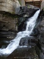
Waterfall Name: Hardenburgh Falls
Aka: ————-
Location: Roxbury Twn
First Visit: 08-10-2014
State: New York State
Region: Central Region
County: Delaware County
Park Area: ————-
NYS Tourism Region: Catskill Mountains
NYDEC Region: Capital Region/Northern Catskills
Waterfall Challenge:————-
Waterfall Location: N42.33767 W74.45106
Parking: N42.33775 W74.45114
Trailhead: ————-
Trail Name, Reference to: ————-
Stream, River: Bear Kill
Height, Type: 15-20ft,Plunge
Elevation: 1150 ft
Level of Difficulty, Hiking Distance: Roadside view
Whitewater Rte, Canoe Rte Map: ————-
Maps: Delorme Atlas & Gazetteer New York State 9th Edition 2011
My Resource: Eastern New York all outdoors Atlas and Field Guide Publication 2008,E6,pg141
Book Resource: Catskill Region Waterfall Guide: Cool Cascades of the Catskills & Shawangunks, Paperback – September 30, 2004, by Russell Dunn, Section I: Waterfalls of the Catskills, Cloves of the Catskills-Near Prattsville,pg92
Brochures, Travel Guides, Visitor Guides: ————-
Trail_URL: ————-
Additional Information: World Waterfall Database
Photos, Information Contributed to other Websites: Dig the Falls
Landmark: Permit Fishing Access
Nearest Intersection: Rte 23 and Intake Rd
Directions: From the intersection of Hwy 30 and Hwy 23 in Grand Gorge, Get on Hwy 23 and drive east for 3 miles. Turn left onto Intake Rd for .2 miles.
Comments, Notes: Fishing Permit required. As soon as you cross the small bridge on intake road the is room for parking on either side of the road. As you cross the bridge the trail will be on the right hand side of the road. Use caution on the trail. When we arrived here there was a fisherman there and when we questioned the access based on the signage and permit, he said we could join him as he was on his way down to fish. Be sure to walk up to the bridge and look upstream for another waterfall.